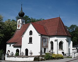
Sankt Radegund
| Sankt Radegund | ||
|---|---|---|
 |
||
|
||
| Location within Austria | ||
| Coordinates: 48°05′48″N 12°45′43″E / 48.09667°N 12.76194°ECoordinates: 48°05′48″N 12°45′43″E / 48.09667°N 12.76194°E | ||
| Country | Austria | |
| State | Upper Austria | |
| District | Braunau am Inn | |
| Government | ||
| • Mayor | Simon Sigl (ÖVP) | |
| Area | ||
| • Total | 17.88 km2 (6.90 sq mi) | |
| Elevation | 480 m (1,570 ft) | |
| Population (14 June 2016) | ||
| • Total | 585 | |
| • Density | 33/km2 (85/sq mi) | |
| Time zone | CET (UTC+1) | |
| • Summer (DST) | CEST (UTC+2) | |
| Postal code | 5121 | |
| Area code | 06278 | |
| Vehicle registration | BR | |
| Website | www.st-radegund.at | |
St. Radegund, also Sankt Radegund is a municipality in the district of Braunau am Inn in the Austrian state of Upper Austria, named after Saint Radegund. It is situated at the western rim of the Innviertel region, where the Salzach river forms the border to the German state of Bavaria.
Originally a part of the stem duchy of Bavaria, Sankt Radegund together with the Innviertel fell to the Archduchy of Austria according to the rules of the 1779 Treaty of Teschen. The village is known as the birthplace of World War II conscientious objector Franz Jägerstätter, who was executed at Brandenburg Prison in 1943.
Sankt Radegund lies in the Innviertel. About 72 percent of the municipality is forest and 22 percent farmland
...
Wikipedia


