San Joaquin Valley, California
| San Joaquin Valley | |
|---|---|

San Joaquin Valley
|
|

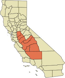
A map of the counties encompassing the San Joaquin Valley ecoregion
|
|
| Location | California, United States |
| Geography | |
| Bounded by | Sierra Nevada (east), Sacramento–San Joaquin River Delta (north), Coast Range, San Francisco Bay (west), Tehachapi Mountains (south) |
| Coordinates | 36°37′44″N 120°11′06″W / 36.62889°N 120.18500°WCoordinates: 36°37′44″N 120°11′06″W / 36.62889°N 120.18500°W |
| Population centers | , Porterville, Modesto, Turlock, Merced, Fresno, Visalia, Bakersfield, Clovis |
| Traversed by | Interstate 5, State Route 99 |
| Watercourses | San Joaquin River |
The San Joaquin Valley /ˌsæn hwɑːˈkiːn/ is the area of the Central Valley of the U.S. state of California that lies south of the Sacramento–San Joaquin River Delta and is drained by the San Joaquin River. It comprises seven Northern California counties—all of Kings County; a majority of Fresno, Merced, Stanislaus counties; segments of Madera and Tulare counties—and a majority of Kern County, in Southern California. Although a majority of the valley is rural, it does contain cities such as Fresno, Bakersfield, , Modesto, Turlock, Porterville, Visalia, Merced, and Hanford.
...
Wikipedia
