Safiental
| Safiental | |
|---|---|

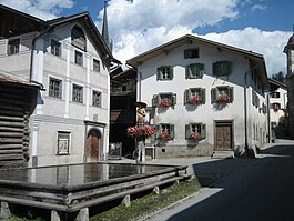
Valendas town center and fountain
|
|
| Coordinates: 46°47′N 9°16′E / 46.783°N 9.267°ECoordinates: 46°47′N 9°16′E / 46.783°N 9.267°E | |
| Country | Switzerland |
| Canton | Graubünden |
| District | Surselva |
| Area | |
| • Total | 151.42 km2 (58.46 sq mi) |
| Population (Dec 2015) | |
| • Total | 896 |
| • Density | 5.9/km2 (15/sq mi) |
| Postal code | 7122/7104/7107/7106 |
| SFOS number | 3672 |
| Surrounded by | Castrisch, Flims, Riein, Sagogn, Bonaduz, Präz, Rhäzüns, Trin, Casti-Wergenstein, Duvin, Flerden, Mathon, Nufenen, Pitasch, Portein, Sankt Martin, Sarn, Splügen, Sufers, Tschappina, Vals |
| Website |
http://gemeinde.safiental.ch SFSO statistics |
Safiental is a municipality in the Surselva Region in the canton of Graubünden in Switzerland. The municipalities of Valendas, Versam, Safien and Tenna merged on 1 January 2013 into the new municipality of Safiental.
Valendas is first mentioned in 765 as in Valendano. Versam is first mentioned in 1050 as a valle Versamia. Safien is first mentioned in 1219 as Stosavia. Tenna is first mentioned in 1398 as Thena.
Formerly inhabited by Romansh speakers, it was settled by the Walser in the late 13th century. Population fell from 1,798 in 1850 to 994 in 1980 and has since stabilized just around 1,000.
Safiental has an area, (as of the 2004/09 survey) of 151.42 km2 (58.46 sq mi). Of this area, about 38.8% is used for agricultural purposes, while 31.1% is forested. Of the rest of the land, 1.2% is settled (buildings or roads) and 29.0% is unproductive land. In the 2004/09 survey a total of 64 ha (160 acres) or about 0.4% of the total area was covered with buildings, an increase of 21 ha (52 acres) over the 1984/85 amount.
Of the agricultural land, 11 ha (27 acres) is used for orchards and vineyards, 1,398 ha (3,450 acres) is fields and grasslands and 4,683 ha (11,570 acres) consists of alpine grazing areas. Since 1984/85 the amount of agricultural land has decreased by 416 ha (1,030 acres). Over the same time period the amount of forested land has increased by 362 ha (890 acres). Rivers and lakes cover 238 ha (590 acres) in the municipality.
The municipality contains the Safien valley, an alpine valley of the Canton of Graubünden, branching off the Vorderrhein valley.
Safien had an area, as of 2006[update], of 100.6 km2 (38.8 sq mi). Of this area, 45.6% is used for agricultural purposes, while 18.2% is forested. Of the rest of the land, 0.8% is settled (buildings or roads) and the remainder (35.4%) is non-productive (rivers, glaciers or mountains). Safien was the capital of the Safien sub-district of the Surselva district in the mid and upper Safien valley. The valley is drained by the Rabiusa river. The former municipality consists of the village of Safien-Platz (elevation: 1,350 m (4,430 ft)) and scattered hamlets and single farm houses throughout the valley.
...
Wikipedia


