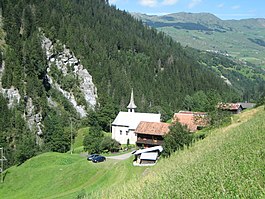
St. Martin, Graubünden
| St. Martin | ||
|---|---|---|
| Former municipality of Switzerland | ||
 |
||
|
||
| Coordinates: 46°40′N 9°10′E / 46.667°N 9.167°ECoordinates: 46°40′N 9°10′E / 46.667°N 9.167°E | ||
| Country | Switzerland | |
| Canton | Graubünden | |
| District | Surselva | |
| Area | ||
| • Total | 22.93 km2 (8.85 sq mi) | |
| Elevation | 1,003 m (3,291 ft) | |
| Population (Dec 2013) | ||
| • Total | 35 | |
| • Density | 1.5/km2 (4.0/sq mi) | |
| Postal code | 7116 | |
| SFOS number | 3598 | |
| Surrounded by | Duvin, Lumbrein, Safien, Suraua, Vals, Vignogn | |
| Website | SFSO statistics |
|
St. Martin (German: Sankt Martin, Romansh: Sogn Martin) is a municipality in the district of Surselva in the Swiss canton of Graubünden. On 1 January 2015 the former municipality of St. Martin merged into the municipality of Vals.
The village was settled around the 14th Century by Walser immigrants. Initially it was a held in fief for the Bishop of Chur by the von Tersnaus and von Mont families. In 1457 the German-speaking population was forbidden from purchasing land or marrying in the neighboring village of Tersnaus. The village church (consecrated 1345) was initially under the parish church of St. Vinzenz in Pleif (in Vella municipality), but in 1528 came under the authority of Tersnaus. After 1776, St. Martin's village church had a German-speaking Prebend though in 1868 it fell back under the authority of Tersnaus.
By 1671 the farm houses of St. Martin's were a neighborhood in Tersnaus, and in 1878 the municipality separated from Tersnaus to become politically independent. The municipality remained firmly rural, and in 1972-73 became the last municipality in Switzerland to be connected to the electric grid.
The municipal coat of arms is Azure, Saint Martin statant clad as bishop argent and or holding in his dexter hand a crosier and his sinister hand raised in blessing, between seven mullets of the last.Saint Martin represents the name of the municipality, while the seven stars represent the seven hamlets that make up the municipality.
Before the merger, St. Martin had a total area of 22.9 km2 (8.8 sq mi). Of this area, 29% is used for agricultural purposes, while 32.5% is forested. Of the rest of the land, 0.3% is settled (buildings or roads) and the remainder (38.2%) is non-productive (rivers, glaciers or mountains).
...
Wikipedia


