Ruoqiang Town
|
Ruoqiang چاقىلىق 若羌镇 |
|
|---|---|
| Town | |

A mosque in Ruoqiang
|
|
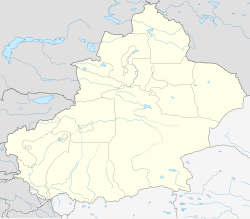
| Location in Xinjiang | |
| Coordinates: 39°01′05″N 88°10′05″E / 39.01806°N 88.16806°ECoordinates: 39°01′05″N 88°10′05″E / 39.01806°N 88.16806°E | |
| Country | China |
| Region | Xinjiang |
| Prefecture | Bayingolin Mongol Autonomous Prefecture |
| County | Ruoqiang |
| Elevation | 897 m (2,943 ft) |
| Time zone | China Standard (UTC+8) |
| Postal code | 841800 |
| Area code(s) | 0966 |
Ruoqiang Town (Chinese: 若羌; pinyin: Ruòqiāng; Uyghur: Чакилик: Qakilik or Charkliq) is a town in Ruoqiang County, Bayin'gholin Mongol Autonomous Prefecture in southeastern Xinjiang, People's Republic of China. Ruoqiang Town is the county seat of the Ruoqiang County, and therefore is the place that less detailed maps label as "Ruoqiang County" or just "Ruoqiang". The postal code is 841 800.
There is a two-laned asphalt highway to Korla, 490 km (304 mi) north, and 956 km (594 mi) west to Hotan. There is no motorable road east to Dunhuang in Gansu, but one can now drive southeast through the Altun Shan range and then north through part of the Tsaidam to Dunhuang.
During the latter part of the Former Han and throughout the Later Han the capital of the kingdom of Shanshan was known as Yüni 扜泥, which was located near the present town of Ruoqiang.
Ruoqiang has a cold desert climate (Köppen climate classification BWk) with extreme seasonal variation in temperature. The monthly 24-hour average temperature ranges from −7.4 °C (18.7 °F) in January to 27.5 °C (81.5 °F), and the annual mean is 11.7 °C (53.1 °F). Precipitation totals only 29 millimetres (1.1 in) annually, and mostly falls in summer. No month has less than 60% of possible sunshine, and the area receives close to 3,100 hours of bright sunshine annually.
...
Wikipedia

