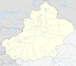
Ruoqiang County
|
Ruoqiang (Qarkilik) County 若羌县 • چاقىلىق ناھىيىسى |
|
|---|---|
| County | |
 Ruoqiang County (red) within Bayingolin Prefecture (yellow) and Xinjiang |
|
| Location in Xinjiang | |
| Coordinates: 39°01′N 88°10′E / 39.017°N 88.167°ECoordinates: 39°01′N 88°10′E / 39.017°N 88.167°E | |
| Country | China |
| Region | Xinjiang |
| Autonomous prefecture | Bayingolin |
| County seat | Ruoqiang Town |
| Area | |
| • Total | 198,318 km2 (76,571 sq mi) |
| Elevation | 896 m (2,940 ft) |
| Population (2002) | |
| • Total | 31,877 |
| • Density | 0.16/km2 (0.42/sq mi) |
| Time zone | China Standard (UTC+8) |
| Postal code | 841800 |
| Area code(s) | 0966 |
Ruoqiang (Qarkilik) County (simplified Chinese: 若羌县; traditional Chinese: 婼羌縣; pinyin: Ruòqiāng Xiàn, historically known as Charkliq, Chaqiliq, or Qakilik, Uyghur: چاقىلىق ناھىيىسى, Чақилиқ Наһийиси, ULY: Chaqiliq Nahiyisi) is a county in the Xinjiang Uyghur Autonomous Region, China under the administration of the Bayingolin Mongol Autonomous Prefecture. It covers an area of 198,318 square kilometres (76,571 sq mi) (about twice the size of Zhejiang province and similar to Kyrgyzstan or Senegal), making it the largest county-level division in the country.
As of 2005[update], the county had a population of 31,877, of which 18,957 (59.5%) were of Han ethnicity, while Uyghurs numbered 11,761 (36.9%).
...
Wikipedia

