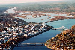
Rovaniemi
| Rovaniemi | ||
|---|---|---|
| Municipality | ||
| Rovaniemen kaupunki Rovaniemi stad | ||

Rovaniemi from air, October 1999
|
||
|
||
 |
||
| Coordinates: 66°30′N 025°44′E / 66.500°N 25.733°ECoordinates: 66°30′N 025°44′E / 66.500°N 25.733°E | ||
| Country |
|
|
| Region |
|
|
| Sub-region | Rovaniemi sub-region | |
| Charter | 1960 | |
| Government | ||
| • City manager | Esko Lotvonen | |
| Area (2016-01-01) | ||
| • Total | 7,581.86 km2 (2,927.37 sq mi) | |
| • Land | 7,581.97 km2 (2,927.41 sq mi) | |
| • Water | 434.75 km2 (167.86 sq mi) | |
| Area rank | 5th largest in Finland | |
| Population (2016-03-31) | ||
| • Total | 61,784 | |
| • Rank | 16th largest in Finland | |
| • Density | 8.15/km2 (21.1/sq mi) | |
| Population by native language | ||
| • Finnish | 97.6% (official) | |
| • Swedish | 0.1% | |
| • Sami | 0.2% | |
| • Others | 2.1% | |
| Population by age | ||
| • 0 to 14 | 17.1% | |
| • 15 to 64 | 68.1% | |
| • 65 or older | 14.8% | |
| Time zone | EET (UTC+2) | |
| • Summer (DST) | EEST (UTC+3) | |
| Municipal tax rate | 20% | |
| Website | www.rovaniemi.fi | |
| Rovaniemi | ||||||||||||||||||||||||||||||||||||||||||||||||||||||||||||
|---|---|---|---|---|---|---|---|---|---|---|---|---|---|---|---|---|---|---|---|---|---|---|---|---|---|---|---|---|---|---|---|---|---|---|---|---|---|---|---|---|---|---|---|---|---|---|---|---|---|---|---|---|---|---|---|---|---|---|---|---|
| Climate chart () | ||||||||||||||||||||||||||||||||||||||||||||||||||||||||||||
|
||||||||||||||||||||||||||||||||||||||||||||||||||||||||||||
|
||||||||||||||||||||||||||||||||||||||||||||||||||||||||||||
| J | F | M | A | M | J | J | A | S | O | N | D |
|
42
−8
−15
|
34
−8
−14
|
36
−3
−9
|
31
4
−4
|
36
11
2
|
59
17
7
|
69
20
11
|
72
17
9
|
54
10
4
|
55
3
−1
|
49
−3
−8
|
42
−6
−13
|
| Average max. and min. temperatures in °C | |||||||||||
| Precipitation totals in mm | |||||||||||
| Source: World Meteorological Organization | |||||||||||
| Imperial conversion | |||||||||||
|---|---|---|---|---|---|---|---|---|---|---|---|
| J | F | M | A | M | J | J | A | S | O | N | D |
|
1.7
17
6
|
1.3
18
7
|
1.4
27
15
|
1.2
38
25
|
1.4
51
36
|
2.3
62
45
|
2.7
67
52
|
2.8
62
Wikipedia
...
| ||||

