Rosemead, California
| Rosemead, California | ||
|---|---|---|
| City | ||
| City of Rosemead | ||

Valley Boulevard in Rosemead
|
||
|
||
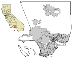
 Location of Rosemead in Los Angeles County, California |
||
| Location in the United States | ||
| Coordinates: 34°4′N 118°5′W / 34.067°N 118.083°WCoordinates: 34°4′N 118°5′W / 34.067°N 118.083°W | ||
| Country | ||
| State |
|
|
| County |
|
|
| Incorporated | August 4, 1959 | |
| Government | ||
| • City council |
Mayor Sandra Armenta, Mayor Pro Tem Polly Low, William Alarcon, Margaret Clark, and Steven Ly |
|
| Area | ||
| • Total | 5.176 sq mi (13.406 km2) | |
| • Land | 5.162 sq mi (13.370 km2) | |
| • Water | 0.014 sq mi (0.035 km2) 0.26% | |
| Elevation | 318 ft (97 m) | |
| Population (April 1, 2010) | ||
| • Total | 53,764 | |
| • Estimate (2013) | 54,561 | |
| • Density | 10,000/sq mi (4,000/km2) | |
| Time zone | PST (UTC-8) | |
| • Summer (DST) | PDT (UTC-7) | |
| ZIP Code | 91770-91772 | |
| Area code(s) | 323/626 | |
| FIPS code | 06-62896 | |
| GNIS feature IDs | 1656611, 2410998 | |
| Website | www |
|
| Rosemead, California | |||||||||||
| Chinese | 柔似蜜市 | ||||||||||
|---|---|---|---|---|---|---|---|---|---|---|---|
|
|||||||||||
| Alternative Chinese name | |||||||||||
| Traditional Chinese | 羅斯密市 | ||||||||||
| Simplified Chinese | 罗斯密市 | ||||||||||
|
|||||||||||
| Transcriptions | |
|---|---|
| Standard Mandarin | |
| Hanyu Pinyin | Róushìmì Shì |
| Yue: Cantonese | |
| Yale Romanization | Yàuhchíhmaht Síh |
| Transcriptions | |
|---|---|
| Standard Mandarin | |
| Hanyu Pinyin | Luósīmì Shì |
| Yue: Cantonese | |
| Yale Romanization | Lòhsīmaht Síh |
Rosemead is a city in Los Angeles County, California, United States. As of the 2010 census, it had a population of 53,764. Rosemead is part of a cluster of cities, along with Arcadia, Temple City, Monterey Park, San Marino, and San Gabriel, in the west San Gabriel Valley with a growing Asian population.
Prior to the arrival of the Spanish, the area around Rosemead was populated by Native Americans of the Tongva, or as the Spaniards renamed them, the Gabrieleños. In 1771, the Spanish founded the first Mission San Gabriel Arcángel in the area that is now known as Whittier Narrows on the border between Montebello and Rosemead. In 1775, the mission moved to avoid the spring floods that ruined the first crops, to its present location in San Gabriel.
During the Spanish Colonial era, the area that is now the City of Rosemead was part of the land administered by the San Gabriel Mission. As part of the Mexican government's Secularization Act of 1833, the land, formerly held by the Mission, was distributed to private citizens, requiring only that they build a house and graze cattle, bringing to an end the Mission Era Following the Mexican-American War and the 1848 signing of the Treaty of Guadalupe which transferred sovereignty over the territory now known as the State of California to the United States, Anglo-American immigration began to flow to the area. The southern part of Rosemead was part of Rancho Potrero Grande (Large Pasture) which was originally granted to a Native American man named Manuel Antonio, who was a "mayordomo" (overseer) at the San Gabriel Mission. The 4,431-acre (18 km2) ranch was later transferred to Juan Matias Sánchez.
...
Wikipedia


