Rogue River National Forest
| Rogue River – Siskiyou National Forest | |
|---|---|
|
IUCN category VI (protected area with sustainable use of natural resources)
|
|

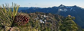
Jeffrey pine on a high ridge
|
|
| Location |
Oregon and California, USA Coos, Curry, Douglas, Jackson, Josephine, and Klamath counties in Oregon Del Norte and Siskiyou counties in California |
| Nearest city | Medford, Oregon |
| Coordinates | 42°03′45″N 123°56′15″W / 42.06250°N 123.93750°WCoordinates: 42°03′45″N 123°56′15″W / 42.06250°N 123.93750°W |
| Area | 1,723,179 acres (697,346 ha) |
| Established | 2004 (1906) |
| Visitors | 915,000 (in 2006) |
| Governing body | U.S. Forest Service |
| Website | Rogue River – Siskiyou National Forest |
The Rogue River – Siskiyou National Forest is a United States National Forest in the U.S. states of Oregon and California. The formerly separate Rogue River and Siskiyou National Forests were administratively combined in 2004. Now, the Rogue River – Siskiyou National Forest ranges from the crest of the Cascade Range west into the Siskiyou Mountains, covering almost 1.8 million acres (7,300 km2). Forest headquarters are located in Medford, Oregon.
The former Rogue River portion of the Rogue River – Siskiyou National Forest is located in parts of five counties in southern Oregon and northern California. In descending order of land area they are Jackson, Klamath, Douglas, Siskiyou, and Josephine counties, with Siskiyou County being the only one in California. It has a land area of 628,443 acres (254,322 ha). There are local ranger district offices located in Ashland, Butte Falls, Grants Pass, Jacksonville, and Prospect.
The former Siskiyou portion of the Rogue River – Siskiyou National Forest is located in parts of four counties in southwestern Oregon and northwestern California. In descending order of land area they are Curry, Josephine, and Coos counties in Oregon and Del Norte County in California. It has a land area of 1,094,726 acres (443,020 ha). There are local ranger district offices located in Cave Junction, Gold Beach, and Powers.
...
Wikipedia

