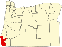
Curry County, Oregon
| Curry County, Oregon | |
|---|---|

Curry County Courthouse in Gold Beach
|
|
 Location in the U.S. state of Oregon |
|
 Oregon's location in the U.S. |
|
| Founded | December 18, 1855 |
| Seat | Gold Beach |
| Largest city | Brookings |
| Area | |
| • Total | 1,988 sq mi (5,149 km2) |
| • Land | 1,627 sq mi (4,214 km2) |
| • Water | 361 sq mi (935 km2), 18.2% |
| Population (est.) | |
| • (2015) | 22,483 |
| • Density | 14/sq mi (5.3/km²) |
| Congressional district | 4th |
| Time zone | Pacific: UTC-8/-7 |
| Website | www |
Curry County is a county in the U.S. state of Oregon. As of the 2010 census, the population was 22,364. The county seat is Gold Beach. The county is named for George Law Curry, a governor of the Oregon Territory.
Curry County comprises the Brookings, OR Micropolitan Statistical Area.
According to the U.S. Census Bureau, the county has a total area of 1,988 square miles (5,150 km2), of which 1,627 square miles (4,210 km2) is land and 361 square miles (930 km2) (18%) is water.
The westernmost point in Oregon is in Curry County at Cape Blanco located at 42°50′08″N 124°33′57″W / 42.835508°N 124.565939°W.
The county contains significant forests, with occurrence of black oak, big leaf maple and Douglas-fir. The blue oak, prevalent slightly further south does not reach into Curry County.
...
Wikipedia
