Riverside Township, New Jersey
| Riverside Township, New Jersey | |
|---|---|
| Township | |
| Township of Riverside | |

Riverside Station on the River Line
|
|
 Riverside Township highlighted in Burlington County. Inset map: Burlington County highlighted in the State of New Jersey. |
|
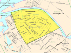
 Census Bureau map of Riverside Township, New Jersey |
|
| Coordinates: 40°02′08″N 74°57′21″W / 40.035677°N 74.955801°WCoordinates: 40°02′08″N 74°57′21″W / 40.035677°N 74.955801°W | |
| Country |
|
| State |
|
| County | Burlington |
| Incorporated | February 20, 1895 |
| Government | |
| • Type | Township |
| • Body | Township Committee |
| • Mayor | George F. Conrad Sr. (D, term ends December 31, 2016) |
| • Administrator | Meghan Jack |
| • Clerk | Susan Dydek |
| Area | |
| • Total | 1.614 sq mi (4.180 km2) |
| • Land | 1.489 sq mi (3.856 km2) |
| • Water | 0.125 sq mi (0.323 km2) 7.73% |
| Area rank | 439th of 566 in state 34th of 40 in county |
| Elevation | 20 ft (6 m) |
| Population (2010 Census) | |
| • Total | 8,079 |
| • Estimate (2015) | 7,997 |
| • Rank | 285th of 566 in state 20th of 40 in county |
| • Density | 5,425.9/sq mi (2,095.0/km2) |
| • Density rank | 100th of 566 in state 1st of 40 in county |
| Time zone | Eastern (EST) (UTC-5) |
| • Summer (DST) | Eastern (EDT) (UTC-4) |
| ZIP code | 08075 |
| Area code(s) | 856 exchanges: 461, 764, 824 |
| FIPS code | 3400563510 |
| GNIS feature ID | 0882098 |
| Website | www |
Riverside Township is a township in Burlington County, New Jersey, United States. As of the 2010 United States Census, the township's population was 8,079, reflecting an increase of 168 (+2.1%) from the 7,911 counted in the 2000 Census, which had in turn declined by 63 (-0.8%) from the 7,974 counted in the 1990 Census.
Riverside was incorporated as a township by an act of the New Jersey Legislature on February 20, 1895, from portions of Delran Township. A portion of the township was annexed by Delran in 1901. The township was named for its location on the Delaware River.
According to the United States Census Bureau, the township had a total area of 1.614 square miles (4.180 km2), including 1.489 square miles (3.856 km2) of land and 0.125 square miles (0.323 km2) of water (7.73%).
The township borders Delanco Township and Delran Township.
The 2010 United States Census counted 8,079 people, 2,959 households, and 2,027 families residing in the township. The population density was 5,425.9 per square mile (2,095.0/km2). The township contained 3,147 housing units at an average density of 2,113.5 per square mile (816.0/km2). The racial makeup of the township was 80.21% (6,480) White, 6.39% (516) Black or African American, 0.26% (21) Native American, 0.95% (77) Asian, 0.05% (4) Pacific Islander, 7.04% (569) from other races, and 5.10% (412) from two or more races. Hispanics or Latinos of any race were 11.34% (916) of the population.
...
Wikipedia
