Rivera, Switzerland
| Rivera | ||
|---|---|---|
| Former municipality of Switzerland | ||

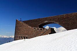
Santa Maria degli Angeli above Rivera village
|
||
|
||
| Coordinates: 46°6′N 8°56′E / 46.100°N 8.933°ECoordinates: 46°6′N 8°56′E / 46.100°N 8.933°E | ||
| Country | Switzerland | |
| Canton | Ticino | |
| District | Lugano | |
| Area | ||
| • Total | 13.35 km2 (5.15 sq mi) | |
| Elevation | 554 m (1,818 ft) | |
| Population | ||
| • Total | 1,462 | |
| • Density | 110/km2 (280/sq mi) | |
| Postal code | 6802 | |
| SFOS number | 5217 | |
| Surrounded by | Bironico, Cadenazzo, Camignolo, Contone, Magadino, Mezzovico-Vira, Sigirino, Vira (Gambarogno) | |
| Website |
www SFSO statistics |
|
Rivera is a former municipality in the district of Lugano in the canton of Ticino in Switzerland. The municipalities of Medeglia, Bironico, Camignolo, Rivera and Sigirino merged on 21 November 2010 into the new municipality of Monteceneri.
Rivera is first mentioned in 1296 as Sorenzino. In 1348 it was mentioned as Rivera.
Archeological objects and graves from the Iron Age and the Roman era have been found in Rivera. In the Middle Ages, Rivera was part of the valley community of Carvina. In the 13th Century Como Cathedral possessed estates in Sorencino. Starting in 1678, representatives from the twelve members of the Swiss Confederation in Ticino met in Casa dei landfogti before they assembled in Lugano.
Rivera was a member of the parish of Bironico, before it became an independent parish in 1754. From 1779 until 1793, the parish church of S. Spirito was rebuilt.
The villagers earned their living from agriculture, mostly in alpine meadows and pastures. During construction of the Ceneri tunnel in 1872-82, the population increased sharply. The completion of the road in 1811 and the construction of the tunnel and the station led to the emergence of a new district in the flatter part of the valley. This area forms the northern boundary of the agglomeration of Lugano. The base station of the Monte Tamaro gondola opened in 1972 in Rivera.
Rivera has an area, as of 1997[update], of 13.35 square kilometers (5.15 sq mi). Of this area, 0.95 km2 (0.37 sq mi) or 7.1% is used for agricultural purposes, while 10.17 km2 (3.93 sq mi) or 76.2% is forested. Of the rest of the land, 1.38 km2 (0.53 sq mi) or 10.3% is settled (buildings or roads), 0.08 km2 (20 acres) or 0.6% is either rivers or lakes and 0.71 km2 (0.27 sq mi) or 5.3% is unproductive land.
...
Wikipedia


