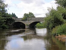
River Blackwater, Ulster
| River Blackwater | |
|---|---|

The bridge over the River Blackwater which connects Charlemont, County Armagh, to The Moy, County Tyrone.
|
|
| Native name | Cluain-Dabhail / An Abhainn Mhór |
| Country | Northern Ireland |
| Basin features | |
| Main source | north of Augher, County Tyrone 59 metres (194 ft) |
| River mouth | Atlantic Ocean at Portstewart |
| Basin size | 1,507 square kilometres (582 sq mi) |
| Tributaries |
|
| Physical characteristics | |
| Length | 91.3 kilometres (56.7 mi) |
| Discharge |
|
The River Blackwater or Ulster Blackwater is a river in County Armagh and County Tyrone, Northern Ireland. It also forms part of the border between the United Kingdom and the Republic of Ireland, flowing between counties Tyrone and Monaghan, intersecting into Monaghan briefly. Its source is to the north of Fivemiletown, County Tyrone. The river divides County Armagh from County Tyrone and also divides County Tyrone from County Monaghan.
The river enters Lough Neagh west of Derrywarragh Island and is navigable from Maghery to Blackwatertown. The small Maghery Canal enters the Blackwater south of Derrywarragh Island. Nearby a small jetty area with a slipway, is the site of the former Maghery ferry. Approximately 4 km from Maghery ferry is the entrance to the river 200m beyond Bond’s Bridge. Just past it, on the east bank, is a large country house estate called the Argory, donated to the National Trust by the McKeogh Bond family. The Callan River joins the Blackwater 1.6 km upstream. Further on, at a bend on the east bank, is the entrance to the first lock of the Ulster Canal. Just upstream, Charlemont Bridge joins the town of Charlemont on the east bank and Moy on the west.
The Blackwater's length is 91.3 km (56.75 mi). If the Blackwater's flow is measured through its path through the 30 km (19 mi) Lough Neagh and onwards to the sea via the 64.4 km (40ml) Lower Bann, the total length is 186.3 km (115.75 mi). This makes the Blackwater–Neagh–Bann the longest natural stream flow in Ulster and is longer than the Munster Blackwater.
...
Wikipedia
