Rio Negro (Amazon)
| Río Negro | |
| Guainía River | |
|
Sunset over the Rio Negro, upstream from Manaus
|
|
| Countries |
|
|---|---|
| Tributaries | |
| - left | Branco River (and many smaller rivers) |
| - right | Vaupés River (and many smaller rivers) |
| Source | highlands of Colombia |
| - location | Guainía Department, Amazon region, Colombia |
| Mouth | Amazon River |
| - location | Manaus, Amazonas State, Brazil |
| - coordinates | 3°08′00″S 59°54′30″W / 3.13333°S 59.90833°WCoordinates: 3°08′00″S 59°54′30″W / 3.13333°S 59.90833°W |
| Length | 2,250 km (1,400 mi) |
| Basin | 691,000 km2 (267,000 sq mi) |
| Discharge | mouth |
| - average | 28,000 m3/s (988,800 cu ft/s) |
|
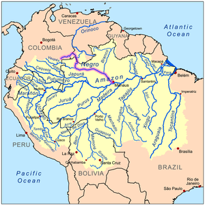
Map showing the Rio Negro in the Amazon Basin
|
|
The Rio Negro (Portuguese: Rio Negro [ˈʁi.u nɛɡɾu]; Spanish: Río Negro [ˈri.o ˈneɣɾo] "Black River") is the largest left tributary of the Amazon, the largest blackwater river in the world, and one of the world's ten largest rivers by average discharge.
The source of the Rio Negro lies in Colombia, in the Department of Guainía where the river is known as Guainía River. The young river generally flows in an east-northeasterly direction through the Puinawai National Reserve, passing several small indigenous settlements on its way, such as Cuarinuma, Brujas, Santa Rosa and Tabaquén. After roughly 400 km the river starts forming the border between Colombia's Department of Guainía and Venezuela's Amazonas State. After passing the Colombian community of Tonina and Macanal the river turns Southwest. Maroa is the first Venezuelan town the river passes. 120 km further downstream the river receives the Casiquiare canal from the right-hand, forming a unique link between the Orinoco and the Amazon river basin. Henceforth the river is called Rio Negro.
The river now continues in a southeastern direction passing the Venezuelan town of San Carlos de Río Negro, its largest settlement on the river, and Colombia's San Felipe. In this stretch the river is constantly fed with tributaries from both sides, and it quickly grows in size creating large river islands, a common feature for all rivers in the Amazon basin. After forming the border between Colombia and Venezuela for 260 km the rio Negro reaches the Piedra del Cocuy, an igneous rock formation from the Precambrian era, belonging to the Guyana Shield. Here the Tripoint of Colombia, Venezuela and Brazil is found in the middle of the river and it now completely enters Amazonas State, Brazil. After passing Cucuí, the river continues south, only temporarily turning west for several kilometers. In Missão Boa Vista the Içana River joins the Rio Negro and in São Joaquim the Uaupes River, the largest tributary of the Rio Negro, also enters from the right hand side. The Rio Negro now turns markedly towards the east, forming several rapids and small islets on its way. It then passes Sao Gabriel da Cachoeira an important commercial city. After several more rapids and imposing views of the Adormecida mountain chain the river leaves the Guyana shield it traversed in its upper and middle course.
...
Wikipedia


