Richmond, Ohio
| Richmond, Ohio | |
|---|---|
| Village | |

Richmond Water Tower
|
|
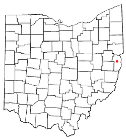
 Location of Richmond, Ohio |
|
 Location of Richmond in Jefferson County |
|
| Coordinates: 40°25′56″N 80°46′21″W / 40.43222°N 80.77250°WCoordinates: 40°25′56″N 80°46′21″W / 40.43222°N 80.77250°W | |
| Country | United States |
| State | Ohio |
| County | Jefferson |
| Township | Salem |
| Area | |
| • Total | 0.55 sq mi (1.42 km2) |
| • Land | 0.55 sq mi (1.42 km2) |
| • Water | 0 sq mi (0 km2) |
| Elevation | 1,243 ft (379 m) |
| Population (2010) | |
| • Total | 481 |
| • Estimate (2012) | 471 |
| • Density | 874.5/sq mi (337.6/km2) |
| Time zone | Eastern (EST) (UTC-5) |
| • Summer (DST) | EDT (UTC-4) |
| ZIP code | 43944 |
| Area code(s) | 740 |
| FIPS code | 39-66824 |
| GNIS feature ID | 1049120 |
Richmond is a village in Jefferson County, Ohio, United States. The population was 481 at the 2010 census. It is part of the Weirton-Steubenville, WV-OH Metropolitan Statistical Area.
During Morgan's Raid of 1863, Confederate Brig. Gen. John Hunt Morgan traveled through the Moorefield, Harrisville, New Athens, Smithfield, New Alexandria, Wintersville, Two Ridge, Richmond, East Springfield, Bergholz, and Monroeville on his way to defeat at the Battle of Salineville.
Richmond was laid out in 1815. A post office called Richmond has been in operation since 1817.
Richmond is located at 40°25′56″N 80°46′21″W / 40.43222°N 80.77250°W (40.432178, -80.772436).
According to the United States Census Bureau, the village has a total area of 0.55 square miles (1.42 km2), all land.
...
Wikipedia
