Richford, Vermont
| Richford, Vermont | |
|---|---|
| Town | |

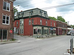
Downtown Richford
|
|
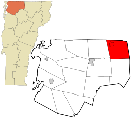
 Location in Franklin County and the state of Vermont. |
|
| Coordinates: 44°59′18″N 72°38′52″W / 44.98833°N 72.64778°WCoordinates: 44°59′18″N 72°38′52″W / 44.98833°N 72.64778°W | |
| Country | United States |
| State | Vermont |
| County | Franklin |
| Area | |
| • Total | 43.3 sq mi (112.1 km2) |
| • Land | 43.0 sq mi (111.4 km2) |
| • Water | 0.3 sq mi (0.7 km2) |
| Elevation | 938 ft (286 m) |
| Population (2010) | |
| • Total | 2,308 |
| • Density | 54/sq mi (20.7/km2) |
| Time zone | Eastern (EST) (UTC-5) |
| • Summer (DST) | EDT (UTC-4) |
| ZIP code | 05476 |
| Area code(s) | 802 |
| FIPS code | 50-59125 |
| GNIS feature ID | 1462185 |
| Website | richfordvt |
Richford is a town in Franklin County, Vermont, United States, located along the Canada–United States border. The population was 2,308 at the 2010 census.
Richford is the birthplace of R. G. LeTourneau, an industrialist who founded LeTourneau University in Longview, Texas.
Richford is the eastern terminus of the Missisquoi Valley Rail-Trail.
Richford is located in the northeast corner of Franklin County, bordered to the north by the Brome-Missisquoi Regional County Municipality in the Montérégie region of Quebec in Canada. Orleans County, Vermont, is to the east. Richford, the primary community, is in the northwest part of the town along the Missisquoi River. Vermont Route 105 passes through the center of town, leading east across the Green Mountains to North Troy and southwest to Enosburg Falls. Vermont Route 139 leads north from the center of Richford 1.5 miles (2.4 km) to the international border.
According to the United States Census Bureau, the town has a total area of 43.3 square miles (112.1 km2), of which 43.0 square miles (111.4 km2) is land and 0.3 square miles (0.7 km2), or 0.61%, is water. The Missisquoi River enters from Canada and exits to the south; there are no significant lakes or ponds.
...
Wikipedia
