Región de Atacama
|
Atacama Region III Región de Atacama |
|||
|---|---|---|---|
| Region of Chile | |||
 |
|||
|
|||
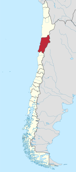
 Map of Atacama Region |
|||
| Coordinates: 27°22′00″S 70°19′56″W / 27.36667°S 70.33222°WCoordinates: 27°22′00″S 70°19′56″W / 27.36667°S 70.33222°W | |||
| Country |
|
||
| Capital | Copiapó | ||
| Provinces | Chañaral, Copiapó, Huasco | ||
| Government | |||
| • Intendant | Miguel Vargas Correa (PS) | ||
| Area | |||
| • Total | 75,176.2 km2 (29,025.7 sq mi) | ||
| Area rank | 4 | ||
| Highest elevation | 6,891.3 m (22,609.3 ft) | ||
| Lowest elevation | 0 m (0 ft) | ||
| Population (2012 census) | |||
| • Total | 284,992 | ||
| • Rank | 11 | ||
| • Density | 3.8/km2 (9.8/sq mi) | ||
| ISO 3166 code | CL-AT | ||
| Website | Official website (Spanish) | ||
The Atacama Region (Spanish: III Región de Atacama pronounced: [ataˈkama]) is one of Chile's 15 first order administrative divisions. It comprises three provinces, Chañaral, Copiapó and Huasco. It is bordered to the north by Antofagasta, to the south by Coquimbo, to east with Provinces of Catamarca, La Rioja and San Juan of Argentina, and to the west by the Pacific Ocean. The regional capital Copiapó is located at 806 km (501 mi) north of the country's capital of Santiago. The region occupies the southern portion of the Atacama Desert, the rest of the desert is mainly distributed among the other regions of Norte Grande
The Atacama Region is the third least populated region of the country, after Aysen and Magallanes. Of its total population, over 50% are located in the cities of Copiapó and Vallenar.
The largest cities are (2002 census data) Copiapó (125,983 inhabitants), Vallenar (43,750), Caldera (12,776), Chañaral (12,086), El Salvador (8,697) Tierra Amarilla (8,578), and Diego de Almagro (7,951).
...
Wikipedia


