
Rees, Germany
| Rees | ||
|---|---|---|
|
||

Rees
|
||
|
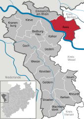
Location of Rees within Kleve district
  |
||
| Coordinates: 51°46′0″N 6°24′0″E / 51.76667°N 6.40000°ECoordinates: 51°46′0″N 6°24′0″E / 51.76667°N 6.40000°E | ||
| Country | Germany | |
| State | North Rhine-Westphalia | |
| Admin. region | Düsseldorf | |
| District | Kleve | |
| Government | ||
| • Mayor | Christoph Gerwers (CDU) | |
| Area | ||
| • Total | 109.66 km2 (42.34 sq mi) | |
| Population (2015-12-31) | ||
| • Total | 21,349 | |
| • Density | 190/km2 (500/sq mi) | |
| Time zone | CET/CEST (UTC+1/+2) | |
| Postal codes | 46459 | |
| Dialling codes | 0 28 51 0 28 50 (Haldern) 0 28 57 (Mehr / Haffen) |
|
| Vehicle registration | KLE | |
| Website | www.stadt-rees.de | |

Rees is a town in the district of Cleves in the state of North Rhine-Westphalia, Germany. It is located on the right bank of the Rhine, approx. 20 km east of Cleves. Population (2005): 22,559. Founded in 1228, Rees is the oldest town in the lower Rhine area.
Rees is administratively organized in eight communities:
The neighbouring municipalities are Oude IJsselstreek (province of Gelderland, NL) and Isselburg (district of Borken) in the North, Hamminkeln and Wesel in the East, Xanten in the South (all district of Wesel), and Kalkar and Emmerich in the West.
Old tower Zollturm
Medieval city wall
Church in Mehr
Church in Haffen
The origin of the town is a Frankish settlement established between 500-800 AD. The name Rees most probably goes back to the Franconian term "Rys", which means "willow grove".
The Lower Rhine area was Christianized by the Irish missionary Willibrord between 657-739. Around 1000 the nearby monastery of Aspel was first mentioned.
On 14 July 1228 Rees was granted municipal rights by Heinrich I von Müllenark, Archbishop of Cologne. At that time it had about 600 inhabitants. In 1289/90 the works on a fortified city wall began, which was completed in 1350. In 1392 Rees and the monastery of Aspel became parts of the County of Cleves.
...
Wikipedia