Reedsville, Wisconsin
| Reedsville, Wisconsin | |
|---|---|
| Village | |
 |
|
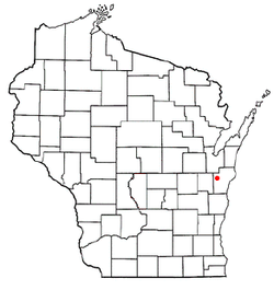
 Location of Reedsville, Wisconsin |
|
| Coordinates: 44°9′14″N 87°57′20″W / 44.15389°N 87.95556°WCoordinates: 44°9′14″N 87°57′20″W / 44.15389°N 87.95556°W | |
| Country | United States |
| State | Wisconsin |
| County | Manitowoc |
| Area | |
| • Total | 1.25 sq mi (3.24 km2) |
| • Land | 1.25 sq mi (3.24 km2) |
| • Water | 0 sq mi (0 km2) |
| Elevation | 827 ft (252 m) |
| Population (2010) | |
| • Total | 1,206 |
| • Estimate (2012) | 1,191 |
| • Density | 964.8/sq mi (372.5/km2) |
| Time zone | Central (CST) (UTC-6) |
| • Summer (DST) | CDT (UTC-5) |
| Area code(s) | 920 |
| FIPS code | 55-66875 |
| GNIS feature ID | 1572174 |
| Website | www |
Reedsville is a village in Manitowoc County, Wisconsin, United States. The population was 1,206 at the 2010 census.
The village was named after Judge George Reed, who, with his partner, Jacob Lueps, bought a section of land in the town of Maple Grove, Wisconsin. In 1854, they had the land platted and surveyed by George Wimpf, who laid out a village of 56 blocks. Early residents of the village were French Canadians and Menomonee Indians. Later, settlers from Germany, Bohemia, and Ireland came. The village was incorporated in 1892, when its population was 510.
Reedsville is located at 44°9′14″N 87°57′20″W / 44.15389°N 87.95556°W (44.153756, -87.955595).
According to the United States Census Bureau, the village has a total area of 1.25 square miles (3.24 km2), all of it land.
As of the census of 2010, there were 1,206 people, 472 households, and 322 families residing in the village. The population density was 964.8 inhabitants per square mile (372.5/km2). There were 513 housing units at an average density of 410.4 per square mile (158.5/km2). The racial makeup of the village was 90.5% White, 2.1% Native American, 6.5% from other races, and 1.0% from two or more races. Hispanic or Latino of any race were 7.8% of the population.
...
Wikipedia
