Red Sea Governorate
| Red Sea Governorate | ||
|---|---|---|
| Governorate | ||
|
||
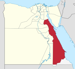
 Red Sea Governorate on the map of Egypt |
||
| Coordinates: 25°32′1″N 33°26′18″E / 25.53361°N 33.43833°ECoordinates: 25°32′1″N 33°26′18″E / 25.53361°N 33.43833°E | ||
| Country |
|
|
| Seat | Hurghada (capital) | |
| Government | ||
| • Governor | Ahmed Abdallah | |
| Area | ||
| • Total | 203,685 km2 (78,643 sq mi) | |
| Population (2014) | ||
| • Total | 337,051 | |
| • Density | 1.7/km2 (4.3/sq mi) | |
| Time zone | EET (UTC+2) | |
| Website | Red Sea | |
Red Sea Governorate (Egyptian Arabic: محافظة البحر الأحمر Muḥāfẓet El Baḥr El Aḥmar) is one of the 27 governorates(States) of Egypt. Located between the Nile and the Red Sea in the southeast of the country, its southern border forms part of Egypt's border with Sudan. Its capital and largest city is Hurghada.
The Red Sea Governorate is bordered on the north by the Suez Governorate, to the east by the Red Sea, and to the west by the governorates of Aswan, Qena, Sohag, Asyut, al-Minya and Beni Suef. In the south it is bordered by Sudan's Red Sea State. It contains the disputed territory of the Hala'ib triangle, including the Siyal Islands.
In addition to the administrative center of Hurghada, about 60,000 residents live in the cities of Ras Gharib, Safaga, El Qoseir, Marsa Alam and Bir Shalatein. The population in 2006 was 288,233 inhabitants, of which more than 275,000 lived in a few towns along the coast. In general, the economic structure of the province's cities and tourist areas is concentrated along the coast. Historically, the population since 1937 was:
...
Wikipedia

