Red Oaks Mill, New York
| Red Oaks Mill, New York | |
|---|---|
| Census-designated place | |

Falls on Wappinger Creek at Red Oaks Mill
|
|
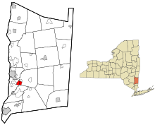
 Location of Red Oaks Mill, New York |
|
| Coordinates: 41°39′5″N 73°52′22″W / 41.65139°N 73.87278°WCoordinates: 41°39′5″N 73°52′22″W / 41.65139°N 73.87278°W | |
| Country | United States |
| State | New York |
| County | Dutchess |
| Towns | LaGrange, Poughkeepsie |
| Area | |
| • Total | 2.31 sq mi (5.97 km2) |
| • Land | 2.28 sq mi (5.90 km2) |
| • Water | 0.03 sq mi (0.08 km2) |
| Elevation | 167 ft (51 m) |
| Population (2010) | |
| • Total | 3,613 |
| • Density | 1,587/sq mi (612.9/km2) |
| Time zone | Eastern (EST) (UTC-5) |
| • Summer (DST) | EDT (UTC-4) |
| FIPS code | 36-60983 |
| GNIS feature ID | 0962312 |
Red Oaks Mill is a hamlet and census-designated place (CDP) in Dutchess County, in the U.S. state of New York. It lies within the limits of the towns of Poughkeepsie and LaGrange. The population was 3,613 at the 2010 census.
Red Oaks Mill is southeast of the city of Poughkeepsie and can be considered a suburb of the city. It is part of the Poughkeepsie–Newburgh–Middletown, New York Metropolitan Statistical Area as well as the larger New York–Newark–Bridgeport, New York-New Jersey-Connecticut-Pennsylvania Combined Statistical Area.
Red Oaks Mill is located at 41°39′05″N 73°52′22″W / 41.651315°N 73.872818°W.Wappinger Creek, a tributary of the Hudson River, flows through the center of the community, forming the border between the towns of Poughkeepsie and LaGrange.
...
Wikipedia
