Dutchess County, New York
| Dutchess County, New York | |||
| County | |||
|
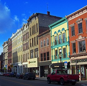
Downtown Poughkeepsie
|
|||
|
|||
| Named for: Duchess of York | |||
| Country | United States | ||
|---|---|---|---|
| State | New York | ||
| Region | Hudson Valley | ||
| River | Hudson | ||
| Highest point | Brace Mountain | ||
| - elevation | 2,311 ft (704 m) | ||
| Lowest point | sea level (at the Hudson River) | ||
| - elevation | 0 ft (0 m) | ||
| Area | 825 sq mi (2,137 km2) | ||
| - land | 796 sq mi (2,062 km2) | ||
| - water | 30 sq mi (78 km2) | ||
| Population | 297,488 (2010) | ||
| Density | 374/km2 (969/sq mi) | ||
| Founded | 1713 | ||
| County Executive | Marcus Molinaro (R) | ||
| Timezone | North American Eastern (EST) (UTC-5) | ||
| - summer (DST) | EDT (UTC-4) | ||
| Area code | 845 and 518 | ||
| Congressional districts | 18th, 19th | ||
| County seat | Poughkeepsie | ||
| Largest city | Poughkeepsie | ||
|
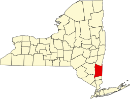
Location of Dutchess County within the state of New York
|
|||
|
Website: www |
|||
Dutchess County is a county located in the southeastern portion of the U.S. state of New York. As of the 2010 census, the population was 297,488. The county seat and largest city is Poughkeepsie. The county was created in 1683 and later organized in 1713.
Dutchess County is part of the New York-Newark-Jersey City, NY-NJ-PA Metropolitan Statistical Area. It is located in the Mid-Hudson Region of the Hudson Valley.
Prior to Anglo-Dutch settlement, what is today Dutchess County was a leading center for the native Wappinger peoples. They had their council-fire at what is now present-day Fishkill Hook, and also held gatherings along the Danskammer. On November 1, 1683, the Province of New York established its first twelve counties, with Dutchess County being one of them. Its boundaries at that time included the present Putnam County, and a small portion of the present Columbia County (the towns of Clermont and Germantown). The county was named for Mary of Modena, Duchess of York, second wife of James, Duke of York (later James II, King of England). is an archaic form of the word duchess.
The Province of New York and the Connecticut Colony negotiated an agreement on November 28, 1683, establishing their border as 20 miles (32 km) east of the Hudson River, north to Massachusetts. The 61,660 acres (249.5 km2) east of the Byram River making up the Connecticut Panhandle were granted to Connecticut, in recognition of the wishes of the residents. In exchange, Rye was granted to New York, along with a 1.81-mile (2.91 km) wide strip of land running north from Ridgefield to Massachusetts alongside the New York counties of Westchester, Putnam then Dutchess, known as "The Oblong". The eastern half of the stub of land in northeast Dutchess County containing Rudd Pond and Taconic State Park is the northernmost extension of The Oblong.
...
Wikipedia


