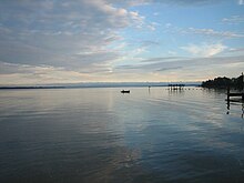
Rappahannock River
| Rappahannock River | |
|---|---|

The Rappahannock at sunset
|
|
 |
|
| Country | United States |
| State | Virginia |
| Counties | Lancaster, Middlesex, Essex, Richmond, Westmoreland, King George, Caroline, Stafford, Spotsylvania, Culpeper, Fauquier, Rappahannock |
| City | Fredericksburg |
| Basin | |
| Main source |
Chester Gap 1,720 feet (520 m) |
| River mouth | Chesapeake Bay |
| Basin size | 2,848 sq mi (7,380 km2) |
| Physical characteristics | |
| Length | 195 miles (314 km) |
| Discharge |
|
The Rappahannock River is a river in eastern Virginia, in the United States, approximately 195 miles (314 km) in length. It traverses the entire northern part of the state, from the Blue Ridge Mountains in the west, across the Piedmont, to the Chesapeake Bay, south of the Potomac River.
An important river in American history, the Rappahannock was the site of early settlements in the Virginia Colony, and, later, was at the center of a major theatre of battle in the American Civil War. Due to its significance as an obstacle to north-south movements, it in effect functioned as the war's eastern-theatre boundary, between the "North" (the Union) and the "South" (the Confederate States of America).
The river drains an area of 2,848 square miles (7,380 km2), approximately 6% of Virginia. Much of the watershed is rural and forested, but it has experienced increased development in recent decades because of the southward expansion of the Washington, D.C. suburbs.
The Rappahannock River rises at Chester Gap, a wind gap in the Blue Ridge Mountains a few miles southeast of Front Royal, Virginia, near the single point where Warren, Fauquier, and Rappahannock counties come together. It flows southeastward, past Remington, Kelly's Ford, and Richardsville, before it is joined by the Rapidan River, its largest tributary, from the right. Then the Rappahannock passes through the city of Fredericksburg. Southeast of Fredericksburg, it begins to slow and widen into a brackish tidal estuary approximately 50 miles (80 km) long. It passes two small, but historic, river towns, Port Royal and Port Conway, which sit opposite each other, the former on the south bank, the latter on the north. Then it flows past Tappahannock on its southern bank, a point where the river is well over a mile wide. The last settlements of any size before reaching the Chesapeake Bay are Irvington, Urbanna, Stingray Point, and White Stone Beach.
...
Wikipedia
