Warren County, Virginia
| Warren County, Virginia | ||
|---|---|---|

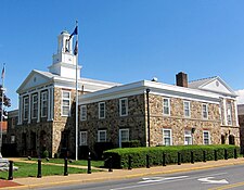
Warren County Courthouse in Front Royal, Virginia
|
||
|
||
 Location in the U.S. state of Virginia |
||
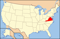
 Virginia's location in the U.S. |
||
| Founded | 1836 | |
| Named for | Joseph Warren | |
| Seat | Front Royal | |
| Largest town | Front Royal | |
| Area | ||
| • Total | 217 sq mi (562 km2) | |
| • Land | 213 sq mi (552 km2) | |
| • Water | 3.3 sq mi (9 km2), 1.5% | |
| Population (est.) | ||
| • (2016) | 39,181 | |
| • Density | 184/sq mi (71/km²) | |
| Congressional district | 6th | |
| Time zone | Eastern: UTC-5/-4 | |
| Website | www |
|
Warren County is a U.S. county located in the Commonwealth of Virginia. As of the 2010 census, the population was 37,575. Its county seat is Front Royal.
Warren County is included in the Washington-Arlington-Alexandria, DC-VA-MD-WV Metropolitan Statistical Area.
Warren County was established in 1836 from Frederick and Shenandoah counties. The county is named for Joseph Warren. During the Civil War the Battle of Front Royal took place in the county on May 23, 1862.
According to the U.S. Census Bureau, the county has a total area of 217 square miles (560 km2), of which 213 square miles (550 km2) is land and 3.3 square miles (8.5 km2) (1.5%) is water.
As of the census of 2000, there were 31,584 people, 12,087 households, and 8,521 families residing in the county. The population density was 148 people per square mile (57/km²). There were 13,299 housing units at an average density of 62 per square mile (24/km²). The demographics of the county is (2000) 92.71% White, 4.83% Black or African American, 0.27% Native American, 0.43% Asian, 0.02% Pacific Islander, 0.46% from other races, and 1.29% from two or more races. 1.56% of the population were Hispanic or Latino of any race.
...
Wikipedia

