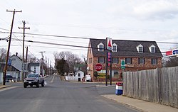
Remington, Virginia
| Remington, Virginia | |
|---|---|
| Town | |

Central Remington
|
|
 Location of Remington, Virginia |
|
| Coordinates: 38°32′8″N 77°48′29″W / 38.53556°N 77.80806°WCoordinates: 38°32′8″N 77°48′29″W / 38.53556°N 77.80806°W | |
| Country | United States |
| State | Virginia |
| County | Fauquier |
| Area | |
| • Total | 0.2 sq mi (0.6 km2) |
| • Land | 0.2 sq mi (0.6 km2) |
| • Water | 0.0 sq mi (0.0 km2) |
| Elevation | 272 ft (83 m) |
| Population (2008) | |
| • Total | 598 |
| • Density | 2,876.4/sq mi (1,110.6/km2) |
| Time zone | Eastern (EST) (UTC-5) |
| • Summer (DST) | EDT (UTC-4) |
| ZIP code | 22734 |
| Area code(s) | 540 |
| FIPS code | 51-66512 |
| GNIS feature ID | 1499948 |
Remington is a small incorporated town in Fauquier County, Virginia, United States. The population was 598 at the 2010 census. It is near the highways, U.S. Route 15, U.S. Route 17, U.S. Route 29, and Virginia State Route 28. Remington is less than a mile northeast of the Culpeper County line.
The town of Remington developed as a transportation hub. It was a commercial port during the mid-nineteenth century on the Rappahannock Canal, but the canal failed financially and operations were abandoned. Later, the town was a stop on the Orange and Alexandria Railroad called Rappahannock Station, but the O&A was eventually absorbed into the Norfolk Southern system, and the Remington spur fell into disuse.
Remington was the site of the First Battle of Rappahannock Station and the Second Battle of Rappahannock Station during the American Civil War. Colonel John S. Mosby made raids in the town during the war, and, later, he made his home and practiced law in nearby Warrenton, Virginia.
The Remington Historic District was listed on the National Register of Historic Places in 2005.
Remington is located at 38°32′8″N 77°48′29″W / 38.53556°N 77.80806°W (38.535464, -77.808117).
...
Wikipedia
