Ramban district
|
Ramban District رام بن |
|
|---|---|
| District | |

District Headquarters, Maitra, Ramban
|
|
 Location in Jammu and Kashmir, India |
|
| Coordinates: 33°14′24″N 75°14′24″E / 33.24000°N 75.24000°ECoordinates: 33°14′24″N 75°14′24″E / 33.24000°N 75.24000°E | |
| Country |
|
| State | Jammu and Kashmir |
| Headquarters | Ramban |
| Area | |
| • Total | 1,329 km2 (513 sq mi) |
| Population (2011) | |
| • Total | 283,713 |
| • Density | 210/km2 (550/sq mi) |
| Languages | |
| • Official | Urdu |
| • Regional | |
| Religion | |
| • Muslims | 70.68% |
| • Hindu | 28.56% |
| • Sikh | 0.27% |
| Time zone | IST (UTC+5:30) |
| Vehicle registration | JK 19 |
| Literacy Rate | 54.27 |
| Famous Personalities | |
| Website | http://ramban.gov.in |
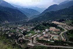
Ramban (Urdu: ضلع رام بن) is one of the 22 districts in the state of Jammu and Kashmir, India. Ramban is located in the lap of Pir Panjal range of the mighty Himalayas. It was carved-out out of erstwhile Doda District keeping in view the backwardness, remoteness and aspiration of people of the area. District Ramban started functioning as independent unit on April 1, 2007. Ramban town is the district headquarters. The town is located midway between Jammu and Srinagar along the Chenab river, on National Highway-44, (originally National Highway 1A (India)) approximately 150 km from Jammu and Srinagar.
Presently District Ramban in Jammu and Kashmir is divided into two tehsils:
Each tehsil has its Tehsildar, who is the administrative head. The district is further divided into four blocks: Ramban, Banihal, Gool and Ramsu. The administrative head of each block is the Block Development Officer (BDO). Each block consists of a number of panchayats. The district consisted of 116 census villages and 127 revenue villages in 2001. The total number of panchayat Halqas in the district is 124.
Ramban district is 1,156 metres (3,792 feet) above sea level. The boundary lines of Ramban district encompass hill station Patnitop as its southernmost point, Assar on its eastern edge, Gool to the west, and Banihal to the north. Terrain of district Ramban is tough and hilly. District Ramban shares its boundary with Reasi, Udhampur, Doda, Anantnag and Kulgam.
The climate of the District varies according to altitude. The temperature rises as high as 42 °C in the low-lying areas like Ramban town located in between steep Mountains on the banks of river Chenab and drops to sub zero in the high altitude areas like Dhagantop. Asthanmarg. Lalagundi, Budhan. The working season in most of the district is about eight months because of typical weather conditions in the district.
Ramban district has two assembly constituencies: Banihal and Ramban.
...
Wikipedia
