Quaiti
| Qu'aiti State in Hadhramaut القعيطي al-Qu‘aytī |
|||||
| State of the Protectorate of South Arabia | |||||
|
|||||
|
Flag |
|||||
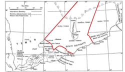
| Map of the Qu'aiti State | |||||
| Capital | Mukalla | ||||
| Government | Sultanate | ||||
| HRH Sultan | Ghalib II bin Awadh Al-Qu'aiti | ||||
| Historical era | 19th and 20th centuries | ||||
| • | Established | 1858 | |||
| • | Disestablished | 30 November 1967 | |||
| Area | 190,000 km2(73,359 sq mi) | ||||
Flag
Qu'aiti (Arabic: القعيطي al-Qu‘ayṭī), officially the Qu'aiti State in Hadhramaut (Arabic: الدولة القعيطية الحضرمية) or the Qu'aiti Sultanate of Shihr and Mukalla (Arabic: سلطنة الشحر والمكلاا al-Salṭanah al-Qu‘ayṭīyah fī ash-Shiḥr wal-Mukallā), was a sultanate in the Hadhramaut region of the southern Arabian Peninsula, in what is now Yemen. Covering approximately 70,000 square miles, roughly the size of England and Wales, Qu'aiti was the third largest kingdom in Arabia after the Kingdom of Saudi Arabia and the Sultanate of Oman. Its capital was Mukalla and it was divided into six provinces including Al-Mukalla, Ash-Shihr, Shibam, Du'an, the Western Province and Hajr.
The Sultanate spanned the Indian Ocean coast up to the border of Mahra, encompassed Shabwa the legendary capital of the Queen of Sheba, the central valleys and oasis settlements of Hadhramaut and controlled the southern Empty Quarter.
Sons of Umar bin Awadh al Qu'aiti, who became a jemadar in the forces of the Nizam of Hyderabad State (now in India), first took the town of Shibam from the rival Kathiris in 1858 to consolidate their rule over all of Hadhramaut. They later conquered Ash Shihr in 1866 and Mukalla in 1881, largely replacing the Kathiris to control most of the Hadhramaut coast on the Gulf of Aden. They entered into treaty relations with the British in 1888 and created a unified sultanate in 1902 that would become a part of the Aden Protectorate.
...
Wikipedia


