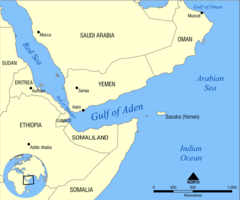
Gulf of Aden
| Gulf of Aden | |
|---|---|

Map of the Gulf of Aden
|
|
| Location | Arabian Sea |
| Coordinates | 12°N 48°E / 12°N 48°ECoordinates: 12°N 48°E / 12°N 48°E |
| Type | Gulf |
| Average depth | 500 m (1,600 ft) |
| Max. depth | 2,700 m (8,900 ft) |
| Max. temperature | 28 °C (82 °F) |
| Min. temperature | 15 °C (59 °F) |
The Gulf of Aden (Arabic: خليج عدن Ḫalīǧ ʻAdan, Somali: Gacanka Cadmeed) is a gulf located in the Arabian Sea between Yemen, on the south coast of the Arabian Peninsula, and Somalia in the Horn of Africa. In the northwest, it connects with the Red Sea through the Bab-el-Mandeb strait, which is more than 20 miles (32 kilometres) wide. It shares its name with the port city of Aden in Yemen, which forms the northern shore of the gulf. Historically, the Gulf of Aden was known as "The Gulf of Berbera", named after the ancient Somali port city of Berbera on the south side of the gulf. However, as the city of Aden grew during the colonial era, the name of "Gulf of Aden" was popularised.
The waterway is part of the important Suez Canal shipping route between the Mediterranean Sea and the Arabian Sea in the Indian Ocean with 21,000 ships crossing the gulf annually.
The name of the Gulf was inspired by the former British Crown Colony city of Aden, now part of Yemen. The Somali names are Gacanka Cadmeed or Gacanka Saylac.
The International Hydrographic Organization defines the limits of the Gulf of Aden as follows:
The temperature of the Gulf of Aden varies between 15 °C (59 °F) and 28 °C (82 °F), depending on the season and the appearance of monsoons. The salinity of the gulf at 10 metres (33 ft) depth varies from 35.3 ‰ along the eastern Somali coast to as high as 37.3 ‰ in the gulf's center, while the oxygen content in the Gulf of Aden at the same depth is typically between 4.0 and 5.0 mg/L.
...
Wikipedia
