Purus-Madeira moist forests
| Purus-Madeira moist forests | |
|---|---|

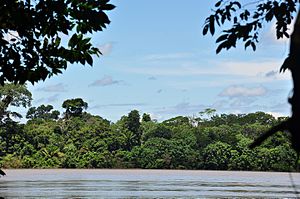
Madeira River from the Mapinguari National Park
|
|
| Ecology | |
| Realm | Neotropical |
| Biome | Tropical and subtropical moist broadleaf forests – Amazon |
| Geography | |
| Country | Brazil |
| Coordinates | 5°43′26″S 62°28′19″W / 5.724°S 62.472°WCoordinates: 5°43′26″S 62°28′19″W / 5.724°S 62.472°W |
The Purus-Madeira moist forests (NT0157) is an ecoregion in the central Amazon basin. It is part of the Amazon biome. The ecoregion covers a stretch of flat and relatively infertile land between the Purus and Madeira rivers, extending to the Solimões River (upper Amazon) in the north. It is isolated from other regions by the seasonally flooded várzea forest along these rivers, and has a high degree of endemism among its flora and fauna. The natural environment is relatively intact. The BR-319 highway was built along the length of the ecoregion in the early 1970s, but rapidly deteriorated and is now closed.
The Purus-Madeira moist forests ecoregion lies to the east of the Carauari arch, an ancient uplift zone in Brazil. The ecoregion stretches from southwest to northeast between the Purus River to the west and the Madeira River to the east, both tributaries of the Solimões River (upper Amazon). In the south it is crossed by the Igapó-Açu River, Ipixuna River, Itaparaná River, Mucuim River, and Jari River.
The large rivers that separate the ecoregion from surrounding regions prevent many species from migrating from or to other regions, making a distinctive environment with various endemic species. The Purus-Madeira moist forests are bounded by the Purus várzea ecoregion along the Purus and the Monte Alegre várzea along the Solimões and Madeira. The Madeira-Tapajós moist forests lie on the east shore of the Madeira. To the south there are stretches of Iquitos várzea in the Southwest Amazon moist forests.
...
Wikipedia
