BR-319
| BR-319 | |
|---|---|

|
|

Bridge on BR-319
|
|
| Route information | |
| Length: | 885 km (550 mi) |
| Existed: | 1976 – present |
| Major junctions | |
| SW end: | Porto Velho – BR-364 |
| Humaitá – BR-230 | |
| NE end: | Manaus – BR-174 |
| Highway system | |
|
Highways in Brazil |
|
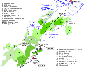
BR-319 is an 870-kilometre (540 mi) federal highway in Brazil that links Manaus in Amazonas to Porto Velho in Rondônia. The highway runs through a pristine part of the Amazon rainforest. It was opened by the military government in 1973 but soon deteriorated, and by 1988 was impassible. In 2008 work began to repair the highway, which will provide an alternative to boat travel along the Madeira River or flying between Manaus and Porto Velho. Protected areas have been created along the route in an effort to prevent deforestation when BR-319 is reopened, a serious concern given the devastation caused elsewhere by highways such as BR-364. As of mid-2016 paving of the middle section of the highway had yet to be approved. Construction permits will depend on measures to prevent future damage to the forest.
The 870-kilometre (540 mi) BR-319 highway connects Manaus, Amazonas, to Porto Velho, Rondônia. The highway runs southeast from Manaus to the Ceasa ferry terminal, where ferries carry vehicles across the Amazon River to the Careiro da Várzea terminal on the south shore. From there the highway runs southwest through the interfluvial region between the Purus and Madeira rivers to Porto Velho. The Purus and Madeira basins together account for about 25% of the Amazon basin.
In 2006 the federal government approved a decree that created the Area under Provisional Administration Limitation (ALAP) on both sides of the road. The ALAP includes almost all the interfluvial region up to Porto Velho, and extends along the west bank of the lower section of the Purus and the Solimões. Within the ALAP only licensed economic activities and public works are allowed. Any other activity that may affect the environment is prohibited. The area of influence of the highway extends about 100 kilometres (62 mi) beyond the ALAP. It is about 553,000 square kilometres (214,000 sq mi), with a population of about 1.3 million as of 2016, of whom 70% live in urban areas.
...
Wikipedia

