Pulau Ubin
| Native name: Pulau Ubin | |
|---|---|

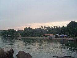
Village on the island
|
|
| Location of Pulau Ubin within Singapore | |
| Etymology | Granite Island |
| Geography | |
| Location | Southeast Asia |
| Coordinates | 1°24′34″N 103°57′36″E / 1.40944°N 103.96000°ECoordinates: 1°24′34″N 103°57′36″E / 1.40944°N 103.96000°E |
| Archipelago | Malay Archipelago |
| Area | 10.19 km2 (3.93 sq mi) |
| Highest point | Bukit Puaka (75m) |
| Administration | |
| Region | North-East Region |
| Planning Area |
|
| CDC | |
| Town council |
|
| Constituency | |
| Member of Parliament | |
| Demographics | |
| Demonym |
|
| Population | 38 (2012) |
| Ethnic groups |
Chinese Singaporean Malay Singaporean |
| Additional information | |
| Official website | Official website |
Pulau Ubin, also simply known as Ubin, is an island situated in the north east of Singapore, to the west of Pulau Tekong. Granite quarrying supported a few thousand settlers on Pulau Ubin in the 1960s, but only about a hundred villagers live there today. It is one of the last rural areas to be found in Singapore, with an abundance of natural flora and fauna. The island forms part of the Ubin–Khatib Important Bird Area (IBA), identified as such by BirdLife International because it supports significant numbers of visiting and resident birds, some of which are threatened.
The name Pulau Ubin literally means "Granite Island" in Malay, which explains the many abandoned granite quarries there. Pulau means "island", and Ubin is said to be a Javanese term for "squared stone". To the Malays, the island is also known as Pulau Batu Ubin, or "Granite Stone Island". The rocks on the island were used to make floor tiles in the past and were called Jubin, which was then shortened to Ubin.
The island is known as tsioh sua in the Taiwanese Romanization of Hokkien, which means "stone hill". The highest point is Bukit Puaka (Puaka Hill) at a height of 75 m.
Legend has it that Pulau Ubin was formed when three animals from Singapore (a frog, a pig and an elephant) challenged each other to a race to reach the shores of Johor. The animals that failed would turn to stone. All three came across many difficulties and were unable to reach the shores of Johor. Therefore, the elephant and pig together turned into Pulau Ubin whilst the frog became Pulau Sekudu or Frog Island.
...
Wikipedia

