Princely State of Porbandar
| Porbandar State પોરબંદર રિયાસત |
|||||
| Princely State of British India | |||||
|
|||||
|
Flag |
|||||
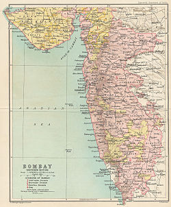
| Porbandar in a map of the Bombay Presidency | |||||
| History | |||||
| • | Established | 1193 | |||
| • | merged into India | 1948 | |||
| Area | |||||
| • | 1931 | 1,647 km2(636 sq mi) | |||
| Population | |||||
| • | 1931 | 115,673 | |||
| Density | 70.2 /km2 (181.9 /sq mi) | ||||
Flag
Porbandar State was a princely state during the British Raj. It was one of the few princely states with a coastline.
The capital of state was the harbour town of Porbandar. Some other important towns of state were Bhanvad, Chhaya, Ranpar and Shrinagar. Earlier Ghumli served as the capital of Jethwas, which was lost to Jadejas, however, architectural heritage built by them still stands at Ghumli. During the British Raj, the state covered an area of 1,663 square kilometres (642 sq mi), encompassing 106 villages and a population, in 1921, of over 100,000 people. It enjoyed a revenue of Rs. 21,00,000/-.
In 1193 Porbandar State was founded by an ancestral ruler expelled from Morvi State. In 1307 the state was renamed 'Ranpur' and in 1574 it was renamed 'Chhaya'. Finally in 1785 the state reverted to the name Porbandar. On 5 December 1809 it became a British protectorate and between 1886 and 15 September 1900 the state was administered by Bombay Province.
In 1888, during the reign of Vikramatji Khimojiraj, the State started metre-gauge railway called Porbandar State Railway, which after independence was merged in to Saurashtra Railway.
Upon the Independence of India in 1947, the state acceded unto the dominion of India. It was merged with the 'United State of Kathiawar', effective from 15 February 1948 and eventually came to form part of the present-day state of Gujarat.
...
Wikipedia


