Postville, Iowa
| Postville, Iowa | |
|---|---|
| City | |
 |
|
| Motto: Hometown to the World | |
 Location of Postville, Iowa |
|
| Coordinates: 43°5′6″N 91°34′10″W / 43.08500°N 91.56944°WCoordinates: 43°5′6″N 91°34′10″W / 43.08500°N 91.56944°W | |
| Country |
|
| State |
|
| Counties | Allamakee, Clayton |
| Township | Post |
| Settled | June 1843 |
| Incorporated | March 11, 1873 |
| Area | |
| • Total | 2.11 sq mi (5.46 km2) |
| • Land | 2.11 sq mi (5.46 km2) |
| • Water | 0 sq mi (0 km2) |
| Elevation | 1,181 ft (360 m) |
| Population (2010) | |
| • Total | 2,227 |
| • Estimate (2012) | 2,186 |
| • Density | 1,055.5/sq mi (407.5/km2) |
| Time zone | Central (CST) (UTC-6) |
| • Summer (DST) | CDT (UTC-5) |
| ZIP code | 52162 |
| Area code(s) | 563 |
| FIPS code | 19-64290 |
| GNIS feature ID | 0460373 |
| Website | www |
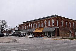
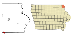
Postville is a city in Allamakee and Clayton Counties in the U.S. state of Iowa. It lies near the junction of four counties and at the intersection of U.S. Routes 18 and 52 and Iowa Highway 51, with airport facilities in the neighboring communities of Waukon, Decorah, Monona, and Prairie du Chien. The population was 2,227 at the 2010 census, down from 2,273 in 2000. The city is located in the southwestern corner of Allamakee County and the northwestern corner of Clayton County in a quad county or four corner region where four counties meet in the same spot. Winneshiek County is just to the west, and Fayette County is located just to the southwest of Postville.
Postville was platted in 1853. The city was named for Joel Post, a pioneer settler.
In 1987, a group of Hasidic Jews started a Kosher slaughterhouse called Agriprocessors, a business which remained in operation until it filed for bankruptcy on November 5, 2008 after a series of complaints of labor law violations and mistreatment of cattle. The facility was raided by the federal government in 2008, resulting in hundreds of arrests of illegal workers.
Postville's longitude and latitude coordinates
in decimal form are 43.085102, -91.569515.
According to the United States Census Bureau, the city has a total area of 2.11 square miles (5.46 km2), all of it land.
As of the census of 2010, there were 2,227 people, 744 households, and 497 families residing in the city. The population density was 1,055.5 inhabitants per square mile (407.5/km2). There were 902 housing units at an average density of 427.5 per square mile (165.1/km2). The racial makeup of the city was 77.0% White, 4.4% African American, 0.6% Native American, 1.0% Asian, 0.7% Pacific Islander, 14.3% from other races, and 2.0% from two or more races. Hispanic or Latino of any race were 32.0% of the population.
...
Wikipedia
