Port Jackson
| Port Jackson | |
|---|---|

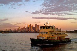
A Sydney Ferries First Fleet-class ferry on Sydney Harbour
|
|
| Location | Sydney, New South Wales |
| Coordinates | 33°51′30″S 151°14′00″E / 33.85833°S 151.23333°ECoordinates: 33°51′30″S 151°14′00″E / 33.85833°S 151.23333°E |
| River sources | Parramatta, Lane Cove, Middle Harbour |
| Ocean/sea sources | Tasman Sea of the South Pacific Ocean |
| Basin countries | Australia |
| Islands | Clark, Shark, Goat, Fort Denison |
| Settlements | Sydney |
Port Jackson, consisting of the waters of Sydney Harbour, Middle Harbour, North Harbour and the Lane Cove and Parramatta Rivers, is the ria or natural harbour of Sydney, New South Wales, Australia. The harbour is an inlet of the Tasman Sea (part of the South Pacific Ocean). It is the location of the Sydney Opera House and Sydney Harbour Bridge. The location of the first European settlement in Australia, Port Jackson has continued to play a key role in the history and development of Sydney.
Many recreational events are based on or around the harbour itself particularly the Sydney New Year's Eve celebrations and the starting point of the Sydney to Hobart yacht race.
The waterways of Port Jackson are managed by the Roads & Maritime Services. Sydney Harbour National Park protects a number of islands and foreshore areas, swimming spots, bushwalking tracks and picnic areas.
The land around Port Jackson was occupied at the time of the European arrival and colonisation by the Eora clans, including the Gadigal, Cammeraygal, and Wangal. The Gadigal occupied the land stretching along the south side of Port Jackson from what is now South Head, in an arc west to the present Darling Harbour. The Cammeragal lived on the northern side of the harbour. The area along the southern banks of the Parramatta River to Rose Hill belonged to the Wangal. The Eora occupied Port Jackson (Sydney Harbour), south to the Georges River and west to Parramatta.
...
Wikipedia
