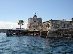
Fort Denison
| Fort Denison | |
|---|---|
|
IUCN category V (protected landscape/seascape)
|
|

Fort Denison with its Martello tower
|
|
|
Location in Sydney
|
|
| Location | Port Jackson, Sydney Harbour National Park |
| Nearest city | Sydney |
| Coordinates | 33°51′17.21″S 151°13′32.26″E / 33.8547806°S 151.2256278°ECoordinates: 33°51′17.21″S 151°13′32.26″E / 33.8547806°S 151.2256278°E |
| Operator | NSW National Parks and Wildlife Service |
| fortdenison |
|
| Location | Sydney Harbour |
|---|---|
| Status | Closed |
| Security class | Maximum; isolation |
| Opened | 1788 |
| Former name | Rock Island |
| Managed by | New South Wales Colonial Government |
| City | Sydney |
| State | New South Wales |
| Country | Australia |
| Fort Denison | |
|---|---|

Fort Denison pre-1885.
(Image: National Archives of Australia) |
|
| Former names | Pinchgut |
| Etymology | Sir William Thomas Denison |
| General information | |
| Status | Built as a fortress. Decommissioned circa 1930s. Now used as a national park; reserve; tourist facility; function space |
| Type | Military fortress; gunnery |
| Architectural style | Colonial fortification, castellated style |
| Location | Sydney Harbour |
| Address | North of Woolloomooloo |
| Construction started | 1841 |
| Completed | 14 November 1857 |
| Closed | circa 1930s |
| Height | |
| Observatory | Martello tower |
| Technical details | |
| Material | Sydney sandstone |
| Designations | Register of the National Estate (21 March 1978) |
| References | |
Fort Denison, part of Sydney Harbour National Park, is a protected national park that is a former penal site and defensive facility occupying a small island located north-east of the Royal Botanic Gardens and approximately 1 kilometre (0.62 mi) east of the Opera House in Sydney Harbour, New South Wales, Australia. The island was formerly known as Pinchgut Island.
In 1978 the former fortress was listed on the Register of the National Estate, and is now used as a national park, nature reserve, tourist facility, and as a function space.
Prior to European settlement, the island had the Eora name Mat-te-wan-ye (sometimes Mallee’wonya).
After the First Fleet arrived in 1788, Governor Phillip and his advocate-general used the name Rock Island. In 1788, a convict named Thomas Hill was sentenced to a week on bread and water in irons there, after a time the island came to be known as Pinchgut. Once a 15-metre (49 ft) high or higher sandstone islet, the rock was levelled by convicts under the command of Captain George Barney, the civil engineer for the colony, who quarried it for sandstone to construct nearby Circular Quay.
In late 1796 the Governor had installed a gibbet on Pinchgut. A convict to be hanged and then gibbeted there was Francis Morgan. In 1793, the British transported him to New South Wales for life as punishment for a murder. The authorities in NSW executed Morgan for bashing Simon Raven to death in Sydney on 18 October 1796. On 30 November 1796, Morgan was hanged for the brutal murder of Simon Raven. Following his execution his body was hung in chains (gibbeting) on Pinchgut. His skeleton was still hanging there four years after his execution. He said to the hangman that the only thing worth mentioning was the superb view of the harbour from his high elevation, and that he was sure there were no waters the world over to compare with it for beauty.
...
Wikipedia

