Sydney Harbour National Park
|
Sydney Harbour National Park New South Wales |
|
|---|---|
|
IUCN category V (protected landscape/seascape)
|
|

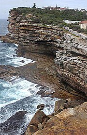
The Gap bluff in the national park at South Head.
|
|
| Nearest town or city | Sydney |
| Coordinates | 33°47′48″S 151°17′30″E / 33.79667°S 151.29167°ECoordinates: 33°47′48″S 151°17′30″E / 33.79667°S 151.29167°E |
| Established | 4 April 1975 |
| Area | 3.92 km2 (1.5 sq mi) |
| Managing authorities | NSW National Parks and Wildlife Service |
| Website | Sydney Harbour National Park |
| See also | Protected areas of New South Wales |
The Sydney Harbour National Park is a protected national park comprising parts of Sydney Harbour, its foreshores and various islands. The 392-hectare (970-acre) national park lies within the Sydney metropolitan area and was created progressively, from 1975.
The national park protects the landforms of Bradleys Head, Clark Island, Dobroyd Head, Fort Denison, Georges Head, Goat Island, Middle Head, Nielsen Park, Rodd Island, Shark Island, Sydney Heads including the Quarantine Station at North Head and The Gap bluff at South Head. The national park also protects the waterway between North Head and Dobroyd Head, defined as the North Sydney Harbour Aquatic Reserve. Parts of the national park lie outside the harbour and face the Tasman Sea.
The national park is managed by the NSW National Parks and Wildlife Service.
The national park is renowned for its sheltered beaches, tranquil picnic spots, rich Aboriginal, colonial and military heritage, aquatic reserves and harbour islands.
The Guringai Resting Places, at both Reef Beach and Quarantine Station, are Aboriginal reburial sites where ancestral remains have been returned to Country. Access to the Aboriginal burial sites is restricted at the request of the Aboriginal community.
...
Wikipedia

