Pittsburg, New Hampshire
| Pittsburg, New Hampshire | |
|---|---|
| Town | |

Park in Pittsburg
|
|
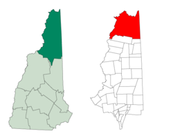
 Location in Coos County, New Hampshire |
|
| Coordinates: 45°03′04″N 71°23′29″W / 45.05111°N 71.39139°WCoordinates: 45°03′04″N 71°23′29″W / 45.05111°N 71.39139°W | |
| Country | United States |
| State | New Hampshire |
| County | Coos |
| Incorporated | 1840 |
| Named for | William Pitt, 1st Earl of Chatham |
| Government | |
| • Board of Selectmen | Steve Ellis, Chair Brendon K. McKeage Richard Lapoint |
| Area | |
| • Total | 291.2 sq mi (754.1 km2) |
| • Land | 281.4 sq mi (728.7 km2) |
| • Water | 9.8 sq mi (25.4 km2) 3.37% |
| Elevation | 1,322 ft (403 m) |
| Population (2010) | |
| • Total | 869 |
| • Density | 3.0/sq mi (1.2/km2) |
| Time zone | Eastern (UTC-5) |
| • Summer (DST) | Eastern (UTC-4) |
| ZIP code | 03592 |
| Area code(s) | 603 |
| FIPS code | 33-61780 |
| GNIS feature ID | 0871099 |
| Website | www |
Pittsburg is a town in Coos County, New Hampshire, United States. The population was 869 at the 2010 census. It is the northernmost town in New Hampshire and the largest town by area in the state – and in New England as well – more than twice the size of the next largest town, Lincoln. U.S. Route 3 is the only major highway in the town, although the northern terminus of New Hampshire Route 145 also lies within Pittsburg.
Pittsburg is part of the Berlin, NH–VT Micropolitan Statistical Area.
Pittsburg derives its name from William Pitt, Prime Minister of the United Kingdom. Prior to its incorporation in 1840, the area was settled c. 1810 and known as the Territory of Indian Stream. It had the unique distinction of having been its own microstate briefly during the 1830s, called the Republic of Indian Stream, due to an ambiguous boundary between the United States and Canada.
Pittsburg shares an international border with Québec province, Canada to its west and north, and borders the states of Maine (to the east) and Vermont (a very small portion to the southwest). Directly to the south is Clarksville. Pittsburg is the only New Hampshire municipality to border Canada, the only one that borders both Maine and Vermont, the only one to share a land border with Vermont, and the only town entirely north of the 45th parallel. Pittsburg contains the only part of New Hampshire west of the Connecticut River, as that river defines the Vermont state line from Clarksville southward. New Hampshire's only Canadian border crossing is located at the northern end of town at the terminus of U.S. Route 3. The western edge of Pittsburg is defined by Halls Stream, being the "northwesternmost headwaters of the Connecticut River", which defined (ambiguously) the border in the Treaty of Paris of 1783.
...
Wikipedia
