Pishtaka River
| Fox River | |
|---|---|

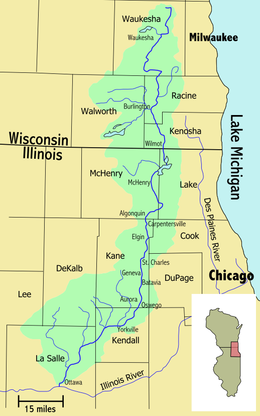
Fox River and its watershed
|
|
| Country | United States |
| States | Wisconsin, Illinois |
| Basin features | |
| Main source | 1 mi (1.6 km) southeast of Colgate, Wisconsin 942.78 ft (287.36 m) 43°11′09″N 88°11′42″W / 43.18583°N 88.19500°W |
| River mouth |
Illinois River at Ottawa, Illinois 460.28 ft (140.29 m) 41°20′37″N 88°50′26″W / 41.34361°N 88.84056°WCoordinates: 41°20′37″N 88°50′26″W / 41.34361°N 88.84056°W |
| Progression | Illinois River-Mississippi River |
| River system | Mississippi River |
| Tributaries |
|
| Waterbodies | Chain O'Lakes |
| Physical characteristics | |
| Length | 202 mi (325 km) |
The Fox River is a 202-mile-long (325 km)tributary of the Illinois River, flowing from southeastern Wisconsin to Ottawa, Illinois in the United States. The Wisconsin section was known as the Pishtaka River in the 19th century. There are two other "Fox Rivers" in southern Illinois: the Fox River (Little Wabash tributary) and a smaller "Fox River" that joins the Wabash River near New Harmony, Indiana.
The Fox River rises in the Halbach Swamp, 1 mi (1.6 km) southeast of the community of Colgate, Wisconsin and flows past Brookfield, Waukesha, Big Bend, Waterford, Rochester, Burlington, Wheatland, Silver Lake and Wilmot, for a total of 84 miles (135 km) in Wisconsin.
A major dam in Waterford forms a 1,200-acre (4.9 km2) navigable waterway which is one of the busiest in southeastern Wisconsin. The river is generally navigable from the Iron Bridge (now a concrete bridge) in Tichigan, Wisconsin (just south of Big Bend) down to the dam. The river connects several small lakes in this section, and one large lake, Tichigan Lake and one smaller lake, Buena Lake. The entire area including connected lakes and the Fox are often referred to as Tichigan Lake.
...
Wikipedia
