Pine Plains (CDP), New York
| Pine Plains, New York | |
|---|---|
| Census-designated place | |
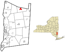
 Location of Pine Plains, New York |
|
| Coordinates: 41°58′44″N 73°39′41″W / 41.97889°N 73.66139°WCoordinates: 41°58′44″N 73°39′41″W / 41.97889°N 73.66139°W | |
| Country | United States |
| State | New York |
| County | Dutchess |
| Town | Pine Plains |
| Area | |
| • Total | 2.3 sq mi (6.0 km2) |
| • Land | 2.1 sq mi (5.4 km2) |
| • Water | 0.2 sq mi (0.6 km2) |
| Elevation | 469 ft (143 m) |
| Population (2010) | |
| • Total | 1,353 |
| • Density | 651/sq mi (251.4/km2) |
| Time zone | Eastern (EST) (UTC-5) |
| • Summer (DST) | EDT (UTC-4) |
| ZIP code | 12567 |
| Area code(s) | 518 |
| FIPS code | 36-58145 |
| GNIS feature ID | 0960532 |
Pine Plains is a hamlet and census-designated place (CDP) in Dutchess County, New York, United States. The population was 1,353 at the 2010 census. It is part of the Poughkeepsie–Newburgh–Middletown, NY Metropolitan Statistical Area as well as the larger New York–Newark–Bridgeport, NY-NJ-CT-PA Combined Statistical Area.
The community of Pine Plains is in the town of Pine Plains.
Pine Plains is located near the northern edge of Dutchess County at 41°58′43″N 73°39′40″W / 41.97861°N 73.66111°W (41.97882, -73.661254), in the central portion of the town of Pine Plains. It is bordered to the northeast by Shekomeko Creek, a tributary of the Roeliff Jansen Kill, which flows northwest to the Hudson River.
...
Wikipedia
