Pichayevsky District
| Pichayevsky District Пичаевский район (Russian) |
|
|---|---|
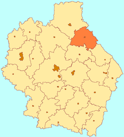
 Location of Pichayevsky District in Tambov Oblast |
|
| Coordinates: 53°14′06″N 42°12′06″E / 53.23500°N 42.20167°ECoordinates: 53°14′06″N 42°12′06″E / 53.23500°N 42.20167°E | |
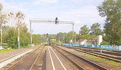
 Vernadovka Station, Syzran-Vyazma railway. |
|
| Location | |
| Country | Russia |
| Federal subject | Tambov Oblast |
| Administrative structure (as of April 2012) | |
| Administrative center | selo of Pichayevo |
| Administrative divisions: | |
| selsoviet | 10 |
| Inhabited localities: | |
| Rural localities | 60 |
| Municipal structure (as of April 2012) | |
| Municipally incorporated as | Pichayevsky Municipal District |
| Municipal divisions: | |
| Urban settlements | 0 |
| Rural settlements | 10 |
| Statistics | |
| Area | 1,294 km2 (500 sq mi) |
| Population (2010 Census) | 14,027 inhabitants |
| • Urban | 0% |
| • Rural | 100% |
| Density | 10.84/km2 (28.1/sq mi) |
| Time zone | MSK (UTC+03:00) |
| Official website | |
| on | |
Pichayevsky District (Russian: Пича́евский райо́н) is an administrative and municipal district (raion), one of the twenty-three in Tambov Oblast, Russia. It is located in the northeast of the oblast. The district borders with Morshansky District in the north, Zemetchinsky District of Penza Oblast in the east, Bondarsky District in the south, and with Sosnovsky District in the west. The area of the district is 1,294 square kilometers (500 sq mi). Its administrative center is the rural locality (a selo) of Pichayevo. Population: 14,027 (2010 Census);16,542 (2002 Census);19,407 (1989 Census). The population of Pichayevo accounts for 24.3% of the district's total population.
Pichayevsky District is in the north-east of Tambov Oblast, about 50 km northeast of the city of Tambov, and 15 km southeast of Morshansk. Three rivers run south to north through the district: the Kersha, the Big Lomovis, and the Kashma. 76.4% of the area is employed agriculture; the soils are chernozems (black earth). Forests cover 17.9% of territory (mostly on the west side), with cover of pine, oak, birch and aspen.
The district is roughly triangular in shape, measuring about 35 km north-south and 50 km west-east across the base. The administrative center of the district is the city of Pichaevo. Subdivisions of the district include 10 rural settlements.
...
Wikipedia
