Petersham, Massachusetts
| Petersham, Massachusetts | ||
|---|---|---|
| Town | ||

|
||
|
||
 Location in Worcester County and the state of Massachusetts. |
||
| Coordinates: 42°29′15″N 72°11′15″W / 42.48750°N 72.18750°WCoordinates: 42°29′15″N 72°11′15″W / 42.48750°N 72.18750°W | ||
| Country | United States | |
| State | Massachusetts | |
| County | Worcester | |
| Settled | 1733 | |
| Incorporated | 1754 | |
| Government | ||
| • Type | Open town meeting | |
| Area | ||
| • Total | 68.3 sq mi (176.9 km2) | |
| • Land | 54.2 sq mi (140.5 km2) | |
| • Water | 14.1 sq mi (36.4 km2) | |
| Elevation | 1,080 ft (329 m) | |
| Population (2010) | ||
| • Total | 1,234 | |
| • Density | 22.8/sq mi (8.8/km2) | |
| Time zone | Eastern (UTC-5) | |
| • Summer (DST) | Eastern (UTC-4) | |
| ZIP code | 01366 | |
| Area code(s) | 351 / 978 | |
| FIPS code | 25-53120 | |
| GNIS feature ID | 0619486 | |
| Website | townofpetersham |
|
| County-level state agency heads | |
|---|---|
| Clerk of Courts: | Dennis P. McManus (D) |
| District Attorney: | Joseph D. Early, Jr. (D) |
| Register of Deeds: | Anthony J. Vigliotti (D) |
| Register of Probate: | Stephanie K. Fattman (R) |
| County Sheriff: | Lew Evangelidis (R) |
| State government | |
| State Representative(s): | Susannah Whipps Lee (R) |
| State Senator(s): | Anne Gobi (D) |
| Governor's Councilor(s): | Jen Caissie (R) |
| Federal government | |
| U.S. Representative(s): | James P. McGovern (D-2nd District), |
| U.S. Senators: | Elizabeth Warren (D), Ed Markey (D) |
Petersham (pronounced "Peter Sam") is a town in Worcester County, Massachusetts, United States. The population was 1,234 at the 2010 census. Petersham is home to a considerable amount of conservation land, including the Quabbin Reservation, Harvard Forest, the Swift River Reservation, and Federated Women's Club State Forest.
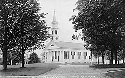
Petersham was first settled in 1733 and was officially incorporated in 1754. On February 4, 1787, it was the site of the second battle of Shays' Rebellion. The town is noted for its common, part of the Petersham Common Historic District. About 45 buildings are listed on the National Register of Historic Places. The Country Store, an 1842 Greek Revival structure that has housed a general store on its main floor since its opening, sits just to the East of the common.
The town's lands were expanded greatly by the building of the Quabbin Reservoir in 1938. When the towns of the Swift River Valley were disincorporated, Petersham and neighboring New Salem benefited the most, with Petersham receiving all of the former town of Dana, much of the town of Greenwich, and a small portion of the former town of Prescott east of the Middle Branch of the Swift River. Its modern southwestern borders lie along the former East and Middle branches of the Swift River, and includes lands that were once part of Hampshire County.
...
Wikipedia

