Petawawa, Ontario
| Petawawa | |
|---|---|
| Town (lower-tier) | |
| Town of Petawawa | |

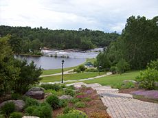
Emerald Necklace Trail and the Petawawa River
|
|
| Coordinates: 45°54′N 77°17′W / 45.900°N 77.283°W | |
| Country |
|
| Province |
|
| County | Renfrew |
| Incorporated (town) | July 1, 1997 |
| Government | |
| • Mayor | Bob Sweet |
| • Governing Body | Petawawa Town Council |
| • MPs | Cheryl Gallant |
| • MPP | John Yakabuski |
| Area | |
| • Land | 164.68 km2 (63.58 sq mi) |
| Population (2011) | |
| • Total | 15,988 |
| • Density | 97.1/km2 (251/sq mi) |
| Source: Canada 2011 Census | |
| Time zone | EST (UTC-5) |
| • Summer (DST) | EDT (UTC-4) |
| Website | Town of Petawawa |
Petawawa is a town located in eastern portion of Southern Ontario. Situated in the Ottawa Valley, with a population of 15,988 (2011 Census). Petawawa is the most populous municipality in Renfrew County.
Petawawa is located at latitude 45°54' north and longitude 77°17' west.
The town lies on the west bank of the Ottawa River, at the confluence of the Petawawa River. Situated across the Ottawa River from the Laurentian Mountains, and east of Algonquin Park, Petawawa is a favourite stop for outdoor enthusiasts, anglers, hikers, canoers, and kayakers.
Ontario Highway 17, Greyhound bus lines, Ontario Northlands bus service from Ottawa and the local commercial airport (Pembroke Airport) located in Petawawa, all provide access to this town.
Petawawa's primary employer is the Canadian Government. Most of Petawawa's residents work as civilian employees, or as members of the Canadian Forces at CFB Petawawa which is home to 2 Canadian Mechanized Brigade Group, and 4 Canadian Division Support Group
...
Wikipedia

