Peru (CDP), New York
| Peru, New York | |
|---|---|
| Census-designated place | |
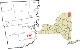
 Location in Clinton County and the state of New York. |
|
| Coordinates: 44°34′46″N 73°31′50″W / 44.57944°N 73.53056°WCoordinates: 44°34′46″N 73°31′50″W / 44.57944°N 73.53056°W | |
| Country | United States |
| State | New York |
| County | Clinton |
| Town | Peru |
| Area | |
| • Total | 1.6 sq mi (4.1 km2) |
| • Land | 1.6 sq mi (4.1 km2) |
| • Water | 0.0 sq mi (0.0 km2) |
| Elevation | 335 ft (102 m) |
| Population (2010) | |
| • Total | 1,591 |
| • Density | 1,001/sq mi (386.4/km2) |
| Time zone | Eastern (EST) (UTC-5) |
| • Summer (DST) | EDT (UTC-4) |
| ZIP code | 12972 |
| Area code(s) | 518 |
| FIPS code | 36-57364 |
| GNIS feature ID | 0960223 |
Peru is a hamlet and census-designated place (CDP) within the town of Peru in Clinton County in the U.S. state of New York. The population of the CDP was 1,591 at the 2010 census, out of a population of 6,998 in the town as a whole.
The hamlet of Peru is located east of the geographic center of the town of Peru, at 44°34′46″N 73°31′49″W / 44.57944°N 73.53028°W (44.579556, -73.530539). It is situated on the Little Ausable River, which flows east 6 miles (10 km) to Lake Champlain.
The community is located at the junction of Route 22 and Route 22B. Interstate 87, the Adirondack Northway, passes 1 mile (1.6 km) east of the hamlet, with access from Exit 35. Plattsburgh, the Clinton County seat, is 11 miles (18 km) north, while Keeseville is 6 miles (10 km) to the south.
According to the United States Census Bureau, the Peru CDP has a total area of 1.6 square miles (4.1 km2), all land.
The CDP describes the more densely populated central area within the town. The U.S. census reports data on CDP in order to provide separate demographic reporting for urbanized areas. The population and area reported here are also included in the aggregate values reported for the town as a whole, see: Peru, New York.
...
Wikipedia
