Pernambuco
| State of Pernambuco | |||
|---|---|---|---|
| State | |||
|
|||
| Anthem: Hino de Pernambuco | |||
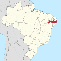
 Location of State of Pernambuco in Brazil |
|||
| Country |
|
||
| Capital and Largest City | Recife | ||
| Government | |||
| • Governor | Paulo Câmara | ||
| • Vice Governor | Raul Henry | ||
| Area | |||
| • Total | 98,311.616 km2 (37,958.327 sq mi) | ||
| Area rank | 19th | ||
| Population (2012) | |||
| • Total | 8,931,028 | ||
| • Rank | 7th | ||
| • Density | 91/km2 (240/sq mi) | ||
| • Density rank | 6th | ||
| Demonym(s) | Pernambucano | ||
| GDP | |||
| • Year | 2007 estimate | ||
| • Total | R$ 32,255,687,000 (10th) | ||
| • Per capita | R$ 4,337 (21st) | ||
| HDI | |||
| • Year | 2010 | ||
| • Category | 0.673 – medium (19th) | ||
| Time zone | BRT (UTC-3) | ||
| • Summer (DST) | BRST (UTC-2) | ||
| Postal Code | 50000-000 to 56990-000 | ||
| ISO 3166 code | BR-PE | ||
| Website | pe.gov.br | ||
Pernambuco (Portuguese pronunciation: [pɛʁnɐ̃ˈbuku]) is a state of Brazil, located in the Northeast region of the country. The state of Pernambuco also includes the archipelago Fernando de Noronha. With an estimated population of 9.2 million people in 2013, it is the seventh most populous state of Brazil, and is the sixth most densely populated and the 19th most extensive among the states and territories of the country. Its capital and largest city, Recife, is one of the most important economic and urban hubs in the country. As of 2013 estimates, Recife's metropolitan area is the fifth most populous in the country, and the largest urban agglomeration in the Northeast Brazil.
In 1982 the city of Olinda, the second oldest city in Brazil, was declared a World Heritage Site by UNESCO. Recife, the state capital and Olinda have one of the most traditional Brazilian Carnivals. Both have architecture of Portugal, with centuries-old casarões and churches, kilometers of beaches and much culture. The proximity of the equator guarantees sunshine throughout the year, with average temperatures of 26 °C (79 °F).
Pernambuco comprises a comparatively narrow coastal zone, a high inland plateau, and an intermediate zone formed by the terraces and slopes between the two.
Its surface is much broken by the remains of the ancient plateau which has been worn down by erosion, leaving escarpments and ranges of flat-topped mountains, called chapadas, capped in places by horizontal layers of sandstone. Ranges of these chapadas form the boundary lines with three states–the Serra dos Irmãos and Serra Vermelha with Piauí, the Serra do Araripe with Ceará, and the Serra dos Cariris Velhos with Paraíba.
...
Wikipedia


