Fernando de Noronha
| Native name: Arquipélago de Fernando de Noronha | |
|---|---|

Do Meio and Conceição beaches
|
|
| Geography | |
| Location | Atlantic Ocean |
| Coordinates | 3°51′13.71″S 32°25′25.63″W / 3.8538083°S 32.4237861°WCoordinates: 3°51′13.71″S 32°25′25.63″W / 3.8538083°S 32.4237861°W |
| Archipelago | Arquipélago de Fernando de Noronha |
| Total islands | 21 |
| Major islands | Fernando de Noronha; Ilha Rata; Ilha do Meio; Ilha Sela Gineta; Ilha Rasa |
| Area | 26 km2 (10 sq mi) |
| Length | 10 km (6 mi) (Fernando de Noronha Island) |
| Width | 3.5 km (2.17 mi) (Fernando de Noronha Island) |
| Highest elevation | 323 m (1,060 ft) |
| Highest point | Morro do Pico |
| Administration | |
| Region | Northeast |
| State | Pernambuco |
| Largest settlement | Vila dos Remédios |
| Demographics | |
| Population | 2,718 (2012) |
| Additional information | |
| Official website | www.noronha.pe.gov.br |
| Official name | Brazilian Atlantic Islands: Fernando de Noronha and Atol das Rocas Reserves |
| Type | Natural |
| Criteria | vii, ix, x |
| Designated | 2001 (25th session) |
| Reference no. | 1000 |
| State Party | Brazil |
| Region | Latin America and the Caribbean |
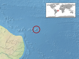
Fernando de Noronha (Portuguese pronunciation: [feʁˈnɐ̃du d(ʒ)i noˈɾoɲɐ]) is an archipelago of 21 islands and islets in the Atlantic Ocean, 354 km (220 mi) offshore from the Brazilian coast. The archipelago got its name from the Portuguese merchant Fernão de Noronha, to whom it was given by the Portuguese crown for services rendered regarding wood imported from Brazil. The main island has an area of 18.4 km2 (7.1 sq mi) and had a population estimated at 2,718 in 2012. The area is a special municipality (distrito estadual) of the Brazilian state of Pernambuco (despite being closer to the state of Rio Grande do Norte), with about 70% established in 1988 as a national maritime park.
In 2001 UNESCO designated it as a World Heritage Site because of the importance of its environment. Its timezone is UTC-02:00 all year round. The local population and travellers can get to Noronha by plane or cruise from Recife, 545 km (339 mi). An environmental preservation fee is charged from tourists upon arrival by Ibama (Institute of Environment and Renewable Natural Resources).
The islands of this archipelago are the visible parts of a range of submerged mountains. It consists of 21 islands, islets and rocks of volcanic origin. The main island has an area of 18 km2 (6.9 sq mi), being 10 km (6.2 mi) long and 3.5 km (2.2 mi) wide at its maximum. The base of this enormous volcanic formation is 756 metres (2,480 ft) below the surface. The volcanic rocks are of variable though mainly silica-undersaturated character with basanite, nephelinite and phonolite among the lava types found. The main island, from which the group gets its name, makes up 91% of the total area; the islands of Rata, Sela Gineta, Cabeluda and São José, together with the islets of Leão and Viúva make up the rest. The central upland of the main island is called the Quixaba.
...
Wikipedia

