Peña Mira
| Sierra de la Culebra | |
|---|---|
| Serra da Coroa | |

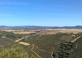
Sierra de la Culebra from afar
|
|
| Highest point | |
| Peak | Peña Mira |
| Elevation | 1,243 m (4,078 ft) |
| Coordinates | 41°53′54″N 6°20′01″W / 41.89833°N 6.33361°WCoordinates: 41°53′54″N 6°20′01″W / 41.89833°N 6.33361°W |
| Dimensions | |
| Length | 95 km (59 mi) ENE/WSW |
| Width | 32 km (20 mi) NNW/SSE |
| Geography | |
| Location |
Vinhais and Bragança municipalities District of Bragança |
| Countries | Portugal and Spain |
| Parent range | Montes de León |
| Geology | |
| Orogeny | Variscan orogeny |
| Age of rock | Ordovician |
| Type of rock | Slates |
Vinhais and Bragança municipalities District of Bragança
The Sierra de la Culebra, Portuguese: Serra da Coroa, is a mountain range in Castile and León, northwest Spain, and northeastern Portugal. It lies 7 km south of Puebla de Sanabria in the comarcas of Aliste, Sanabria and La Carballeda (Zamora Province), as well as Vinhais and Bragança municipalities in the District of Bragança. Its highest point is 1,243 metres (4,078 ft) high Peña Mira, located near Flechas, within Figueruela de Arriba municipal term; other important peaks are Miño Cuevo 1,211 metres (3,973 ft) and Campanario 1,020 metres (3,350 ft).
The Sierra de la Culebra is a 95 km long regular mountain chain of medium height, forming a natural border with the Portuguese region of Tras os Montes on its western end. Its slopes are wooded, occasionally ravaged by forest fires. The summits of the range are often covered with snow in the winter and there are odd-looking rocky quartzite outcrops on them.
Among the rivers in Spain and Portugal having their source in Sierra de la Culebra, the Castro River, Tera, Tuella, Sabor and Maçãs (Manzanas), deserve mention.
...
Wikipedia

