Parvomay
|
Parvomay Първомай |
|
|---|---|
| Town | |
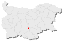
 Position of Parvomay in Bulgaria |
|
| Coordinates: 42°6′N 25°13′E / 42.100°N 25.217°ECoordinates: 42°6′N 25°13′E / 42.100°N 25.217°E | |
| Country | Bulgaria |
| Province | Plovdiv |
| Government | |
| • Mayor | Angel Papazov |
| Elevation | 134 m (440 ft) |
| Population (02.05.2006) | |
| • Town | 16,698 |
| • Urban | 27,230 |
| Time zone | EET (UTC+2) |
| • Summer (DST) | EEST (UTC+3) |
| Postal code | 4270 |
| Area code(s) | 0336 |
Parvomay (Bulgarian: Първомай) is a town Parvomay and the name of the Municipality (Parvomay Municipality) in Southern Bulgaria. It is located in Plovdiv Province region close to the towns Sadovo and Chirpan. The English translation is sometimes given as Parvomai or Purvomai (which literally translated from Bulgarian to English as "First of May").
Although as with many places in Bulgaria it has other names such as its old name (up until 1947), Borisovgrad (after Bulgaria's last Tsar, Boris to celebrate his birthday on 30 January 1894), or Borisovgrad, or Borissograd, or Borissovgrade, or Borissowgrad, until 1894 it was known by its Turkish names Hadzi Ejles (Bulgarian Хаджи Елес), Hadzi-Ele, Hadzi-Jeiles, or the Spanish, Khadzhi Eiles Khadzhi-Eles ("Hacı İlyas" in Turkish).
The municipal centre town Parvomay is situated at 134 meters above sea level, with geographic coordinates 25о13`30`` East longitude and 42о06`00`` North latitude. The town is 180 km to the east of Sofia, 39 km to the east of Plovdiv city, 50 km to the southwest of Stara Zagora, 34 km to the west of city of Haskovo and 360 km to the northwest of Istanbul, the northern edge of the town is 700m south of the Maritza River. The topography of the Parvomay Municipality is predominantly a flat plain with the exception being the fields of the Voden and Bukovo villages and the rolling hills around Iskra, Bryagovo, Dragoinovo and Ezerovo which are from the foot hills of Dragoyna. The name of the ridge comes from a legend about Dragoy, prince of the Slavonic tribe that inhabited the region and his daughter Dragoyna, who built a white stone castle on the peak but the Byzantines conquered and destroyed her residence. This range is in turn the foothills of the Rhodopi mountains, passing to the South-West into the Novakovski Balkan mountain. In 1926, the population of the town was 4425 people, and in 1946 the town was 5050, by 1985 the population had risen to 17,136, by 1992 it had dropped to 16,826. The population of the town in 2009 was 16,630, by the end of 2010 it had fallen to 13,733. The settlement ranks the 57th largest cities of Bulgaria.
...
Wikipedia
