Palo Alto
| Palo Alto, California | |||||
|---|---|---|---|---|---|
| Charter city | |||||
| City of Palo Alto | |||||

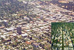
Downtown Palo Alto in 2005
|
|||||
|
|||||
 Location in Santa Clara County and the U.S. state of California |
|||||
| Location in the United States | |||||
| Coordinates: 37°25′45″N 122°8′17″W / 37.42917°N 122.13806°WCoordinates: 37°25′45″N 122°8′17″W / 37.42917°N 122.13806°W | |||||
| Country |
|
||||
| State |
|
||||
| County |
|
||||
| Incorporated | April 23, 1894 | ||||
| Named for | El Palo Alto | ||||
| Government | |||||
| • Type | Council-Manager | ||||
| • Body |
City council members:
|
||||
| Area | |||||
| • Total | 25.787 sq mi (66.787 km2) | ||||
| • Land | 23.884 sq mi (61.858 km2) | ||||
| • Water | 1.903 sq mi (4.929 km2) 7.38% | ||||
| Elevation | 30 ft (9 m) | ||||
| Population (April 1, 2010) | |||||
| • Total | 64,403 | ||||
| • Estimate (2013) | 66,642 | ||||
| • Density | 2,500/sq mi (960/km2) | ||||
| Time zone | Pacific (UTC−8) | ||||
| • Summer (DST) | PDT (UTC−7) | ||||
| ZIP codes | 94301, 94303, 94304, 94306 | ||||
| Area code | 650 | ||||
| FIPS code | 06-55282 | ||||
| GNIS feature IDs | 277572, 2411362 | ||||
| Website | www |
||||
Palo Alto (/ˌpæloʊ ˈæltoʊ/ PAL-oh AL-toh; Spanish: [ˈpalo ˈalto]; from palo, literally "stick", colloquially "tree", and alto "tall"; meaning: "tall tree") is a charter city located in the northwest corner of Santa Clara County, California, in the San Francisco Bay Area of the United States. The city shares its borders with East Palo Alto, Mountain View, Los Altos, Los Altos Hills, Stanford, Portola Valley, and Menlo Park. It is named after a coast redwood tree called El Palo Alto.
...
Wikipedia


