Portola Valley, California
| Portola Valley, California | ||
|---|---|---|
| Town | ||
| Town of Portola Valley | ||

Top of Sand Hill Road, looking back towards Portola Valley and Woodside
|
||
|
||
 Location in San Mateo County and the state of California |
||
| Location in the United States | ||
| Coordinates: 37°22′30″N 122°13′7″W / 37.37500°N 122.21861°WCoordinates: 37°22′30″N 122°13′7″W / 37.37500°N 122.21861°W | ||
| Country | United States | |
| State | California | |
| County | San Mateo | |
| Incorporated | July 14, 1964 | |
| Government | ||
| • Mayor | Maryann Derwin | |
| • Vice Mayor | Craig Hughes | |
| Area | ||
| • Total | 9.093 sq mi (23.551 km2) | |
| • Land | 9.092 sq mi (23.547 km2) | |
| • Water | 0.001 sq mi (0.004 km2) 0.02% | |
| Elevation | 459 ft (140 m) | |
| Population (2010) | ||
| • Total | 4,353 | |
| • Density | 480/sq mi (180/km2) | |
| Time zone | PST (UTC-8) | |
| • Summer (DST) | PDT (UTC-7) | |
| ZIP code | 94028 | |
| Area code | 650 | |
| FIPS code | 06-58380 | |
| GNIS feature ID | 1659786 | |
| Website | www |
|
|
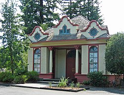
Portola Valley School
|
|
 |
|
| Location | 775 Portola Road |
|---|---|
| Coordinates | 37°22′56″N 122°13′40″W / 37.38222°N 122.22778°W |
| Area | 0.5 acres (0.20 ha) |
| Built | 1904 |
| Architect | LeBaron R Olive |
| Architectural style | Mission/Spanish Revival |
| NRHP Reference # | 74000557 |
| Added to NRHP | June 28, 1974 |
Portola Valley is an incorporated town in San Mateo County, California, United States. It was named for Spanish explorer Gaspar de Portolá, who led the first party of Europeans to explore the San Francisco Peninsula in 1769. The population was 4,353 at the 2010 census.
Portola Valley is one of the forty wealthiest towns in the United States, with a median household income of $244,771 a year. Within the State of California, Portola Valley is ranked as the sixth wealthiest place. The zip code 94028, which encompasses the whole of Portola Valley, has the 9th most expensive housing prices within the country according to Forbes Magazine 2013.
Portola Valley is located at 37°22′30″N 122°13′7″W / 37.37500°N 122.21861°W (37.375023, -122.218635), on the eastern slope of the Peninsula Coastal Range of the Santa Cruz Mountains. The Windy Hill Open Space Preserve is on the town's southwest side and the Jasper Ridge Biological Preserve is on the north side of town. It is off Interstate 280, near Woodside, just west of Palo Alto and Los Altos and south of Menlo Park, and is in a mostly wooded area, with some open plains.
...
Wikipedia


