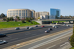
East Palo Alto, California
| City of East Palo Alto | ||
|---|---|---|
| City | ||

University Circle at University Avenue and U.S. Route 101
|
||
|
||
| Nickname(s): E.P.A. | ||
 Location in San Mateo County and the state of California |
||
| Location in the United States | ||
| Coordinates: 37°28′1″N 122°8′23″W / 37.46694°N 122.13972°WCoordinates: 37°28′1″N 122°8′23″W / 37.46694°N 122.13972°W | ||
| Country |
|
|
| State |
|
|
| County | San Mateo | |
| Incorporated | July 1, 1983 | |
| Government | ||
| • Mayor | Donna Rutherford | |
| • Vice Mayor | Larry Moody Sr. | |
| • Councilmember | Ruben Abrica | |
| • Councilmember | Lisa Yarbrough-Gauthier | |
| • Councilmember | Carlos Romero | |
| Area | ||
| • Total | 2.612 sq mi (6.766 km2) | |
| • Land | 2.505 sq mi (6.488 km2) | |
| • Water | 0.107 sq mi (0.278 km2) 4.11% | |
| Elevation | 20 ft (6 m) | |
| Population (2010) | ||
| • Total | 28,155 | |
| • Estimate (2014) | 29,530 | |
| • Density | 11,788/sq mi (4,551/km2) | |
| Time zone | PST (UTC-8) | |
| • Summer (DST) | PDT (UTC-7) | |
| ZIP code | 94303 | |
| Area code(s) | 650 | |
| FIPS code | 06-20956 | |
| GNIS feature ID | 1658461 | |
| Website | www |
|
East Palo Alto (abbreviated E.P.A.) is a city in San Mateo County, California, United States. As of the 2010 census, the population of East Palo Alto was 28,155. It is situated on the San Francisco Peninsula, roughly halfway between the cities of San Francisco and San Jose. To the north and east is the San Francisco Bay, to the west is the city of Menlo Park, and to the south the city of Palo Alto. Despite being called "East" Palo Alto, this is a misnomer, as the city is precisely due north of Palo Alto. While often incorrectly assumed to be part of the city of Palo Alto, East Palo Alto has always been a separate entity since its founding as an unincorporated community. It is also in San Mateo County, while Palo Alto is in Santa Clara County. The two cities are separated only by San Francisquito Creek and, largely, the Bayshore Freeway (the vast majority of East Palo Alto is northeast of the freeway, while all of the residential part of Palo Alto is southwest of the freeway). The revitalization projects in 2000, and high income high-tech professionals moving into new developments, including employees from Google and Facebook, have begun to eliminate the cultural and economic differences between the two cities. East Palo Alto and Palo Alto share both telephone area codes and postal ZIP codes.
About half of East Palo Alto's residents were African Americans in 1990, which was the result of redlining practices and racial deed restrictions in Palo Alto.Latinos now constitute about 65% of the total population, while the proportion of African Americans has decreased to about 15%. A small minority of Pacific Islanders also reside in East Palo Alto, most of Tongan, Samoan and Indo-Fijian origin.. East Palo Alto has the largest concentration of Pacific Islanders of any American city or town outside of Hawaii.
...
Wikipedia


